
A. Gijón Mancheño1*, W.S.J. Uijttewaal1, J.C. Winterwerp1
1 Delft University of Technology, This email address is being protected from spambots. You need JavaScript enabled to view it., This email address is being protected from spambots. You need JavaScript enabled to view it., This email address is being protected from spambots. You need JavaScript enabled to view it.
Introduction
Mangrove vegetation attenuates waves and currents, reduces erosion and enhances sediment deposition (Horstman et al., 2017). It may consequently be a natural tool to combat land subsidence and relative sea level rise, provided that there is enough sediment supply in the system (Horstman et al., 2015).
In the area of Demak, Indonesia, mangrove removal to build aquaculture ponds has resulted in high erosion rates and flooding at the coast. Different types of brushwood and bamboo structures have been built in Demak by the Ecoshape consortium, in order recover the mangrove habitat and enhance natural colonization. The structures reduce wave energy at their lee, providing a calm environment where sediment can settle and mangrove seedlings can establish. However, the current designs were based on engineering judgment, and have provided variable success rates.
Optimizing restoration efforts requires a deeper knowledge of the mangrove habitat, and of which structure designs could reproduce the required physical environment. The present work aims to improve the understanding of the second point; how bamboo and brushwood structures affect the morphodynamic processes, considering different structure configurations and varying hydrodynamic conditions.
Methods
Field measurements were conducted in Demak between November and December of 2018. Measuring frames were placed in front and behind permeable structures, at four different locations (Figure 1).
Each frame contained an Acoustic Doppler Velocimeter (ADV), and an Optical Backscatter sensor (OBS), which monitored the effect of the structures on the morphodynamics. The bathymetries and sediment properties were also regularly measured at each transect.
Results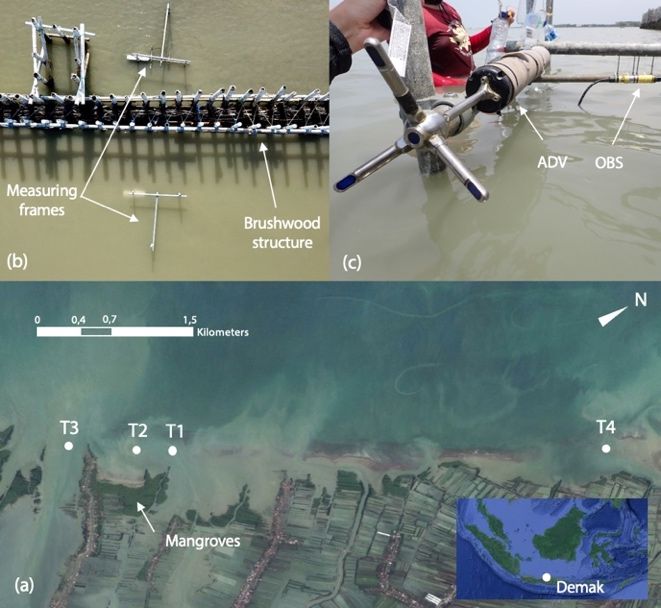
The collected hydrodynamic data will provide information on the rate of wave energy dissipation and reflection produced by different structure configurations.
Parameterizations of the hydrodynamic processes will be derived, in order to implement the structures in larger scale models.
The measurements will also be used for model validation, in order to assess the structure performance over longer timescales. These findings will help develop design tools which can be applied in future restoration efforts.
Figure 1. (a) Location of the monitored transects in Demak. (b) Close-up of transect T4, where instruments were attached at two steel frames. (c) Picture of a Nortek ADV and Campbell OBS in one of the frames.
References
Horstman, E.M., Dohmen-Janssen, C.M., Bouma, T.J. and Hulscher, S.J.M.H., 2015. Tidal-scale flow routing and sedimentation in mangrove forests: Combining field data and numerical modelling. Geomorphology, 228: 244-262.
Horstman, E.M., Mullarney, J.C., Bryan, K.R., Sandwell., D.R., 2017. Deposition gradients across mangrove fringes. Coastal Dynamics 2017 Paper No. 012.