J.L.J. Hanssen1*, B.C. van Prooijen1, P.M.J. Herman1,2, Z.B. Wang1,2
1 Delft University of Technology, 2 Deltares
This email address is being protected from spambots. You need JavaScript enabled to view it., This email address is being protected from spambots. You need JavaScript enabled to view it., This email address is being protected from spambots. You need JavaScript enabled to view it., This email address is being protected from spambots. You need JavaScript enabled to view it.
Intertidal flats provide essential services, like habitats for a range of species and forming a part of the coastal defence system. They are however vulnerable for climate change and human interferences. Large scale changes in hydrodynamic and sediment conditions influence the intertidal flats. In reverse, small scale bio-geomorphology determines the large scale habitat structure and functioning (Weerman, 2011), leading to complex feedback mechanisms between morphology, hydrodynamics and ecology. It is a major challenge to unravel the interconnected dynamics of estuaries in order to quantify the consequences of human interventions and climate change in estuaries.
Different morphological features like channels, gullies and pools in a variety of shapes and patterns can be found on tidal flats (Figure 1). Their influence on the hydrodynamic conditions, sediment fluxes and water storage is highlighted by Whitehouse et al. (2000), but the mechanisms controlling the origin and fate of the features are not well known. Different studies found relations between factors determining the profiles of mudflats. In a classification analysis, Dyer et al. (2000) described these correlations in 13 estuaries in North West Europe based on 20 environmental parameters.
In this PhD research we aim at deriving insight in tipping points and feedback loops governing the morphological features. Relations between development of morphological features and the mudflat or estuary will be used as a generic predictive tool for estuarine development. We will study multiple sites in various estuaries (Western Scheldt, Eastern Scheldt, Humber, Yangtze, Waddensea and Ems-Dollard) having different environmental conditions. Spatial and temporal variations of morphological features are analysed based on historical data (e.g. satellite imagery, hydrodynamic conditions, sedimentology and estuary shape). New data will be gathered from field measurements. This will require advanced technology to measure flow conditions in the gullies with water depths smaller than 0.2 m. We are developing a method using adjusted laboratory instruments in the field.
These insights in the generation and development of these morphological features will be essential to predict the fate/future of intertidal flats for future climate change scenarios and to evaluate management strategies.
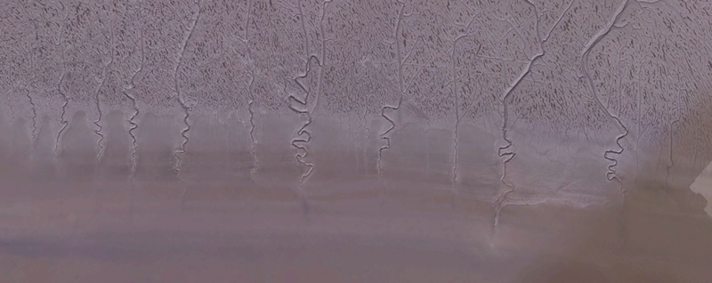
Figure 1: Humber estuary – Pattern of channels on the intertidal flat
References
Barbier, 2011, The value of estuarine and coastal ecosystem services. Ecological Monographs, 81(2), 2011, pp. 169–193
Bouma, T.J. et al., (2014). Identifying knowledge gaps hampering application of intertidal habitats in coastal protection: Opportunities & steps to take. Coastal Engineering 87 147–157.
Dyer, K. R. et al., (2000). The classification of intertidal mudflats. Continental Shelf Research 20 1039-1060
Whitehouse, R.J.S. et al. (2000). The influence of bedforms on flow and sediment transport over intertidal mudflats. Continental Shelf Research 20, 1099-1124.
Weerman, E.J., (2011). Spatial patterns in phototrophic biofilms. PhD Thesis, Radboud University, Nijmegen