
V. Van Lancker1,2, F. Francken1, M. Kapel1, L. Kint1, D. Van den Eynde1, V. Hademenos2, T. Missiaen2,3, R. De Mol4, G. De Tré4, R. Appleton5, S. van Heteren6,*, P.P van Maanen6,7, J. Stafleu6, J. Stam6, K. Degrendele8, M. Roche8
1 Royal Belgian Institute of Natural Sciences, OD Nature, This email address is being protected from spambots. You need JavaScript enabled to view it.
2 Ghent University, Department of Geology
3 present address: Flanders Marine Institute
4 Ghent University, Department of Telecommunications
5 TNO Defence, Security and Safety
6 TNO - Geological Survey of the Netherlands, * This email address is being protected from spambots. You need JavaScript enabled to view it.
7 present address: JOA Scanning Technology
8 FPS Economy, Continental Shelf Service
Context
Mineral and geological resources are non-renewable on time-scales relevant for decision-makers. The sustainable management of these invaluable resources requires a thorough and careful balancing of available quantity and quality versus rapidly changing societal and economical needs. The need for such an approach is recognized in the EU’s Raw Materials Initiative, which highlights the optimization of the geological knowledge base as a key element in ensuring sustainable supplies from within the EU borders. Comprehensive knowledge on the distribution, composition and dynamics of geological resources therefore is the backbone of long-term strategies for resource use in a rapidly changing world.
Results
As a world’s first, a trans-border geological knowledge base is now available for the Belgian and southern Netherlands part of the North Sea comprising volumetric 3D pixel (‘voxel’) models of its subsurface (Figure 1), environmental impact models accounting for geological boundary conditions, a geological data portal, and a voxel-based decision support module on marine aggregate extraction. The newly developed tools assist in the preparation of long-term adaptive management strategies, and in scientifically underpinning new legally binding measures to optimize and maximize long-term exploitation of aggregate resources within sustainable environmental limits. Such measures feed into policy plans that are periodically evaluated and adapted (e.g. Marine Spatial Planning and the Marine Strategy Framework Directive, the environmental pillar of Europe’s Maritime Policy).
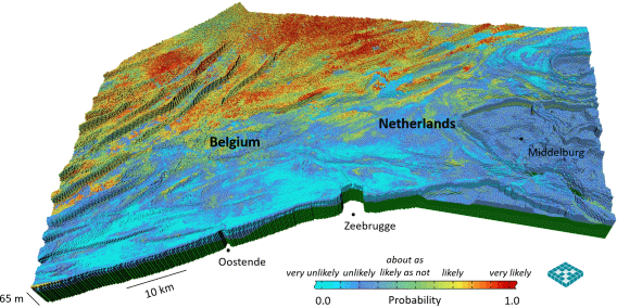
Figure 1 Transnational voxel model of the subsurface offshore Zeeland and Flanders, with probability of medium sand. This surficial view emphasises the top voxel representing the seabed sediment, but also shows the vertical succession of voxels at the coastline (edge of the model), with green representing non-extractable old clay at the base, covered by Pleistocene and Holocene sediment of different size.