
W.J. Gerats1*, T.H. Donders1, M. van der Vegt1
1 Utrecht University
*corresponding author: This email address is being protected from spambots. You need JavaScript enabled to view it.
Introduction
Low lying coastal areas all over the world face are challenged by sea level rise. The evolution of these areas is determined by the creation of so-called accommodation space on the one hand and sediment input on the other. It is of vital importance to predict the response of coastal areas to rising sea levels. However, predictive capabilities of morphodynamic models are uncertain because these models need to be calibrated and validated with field data, which often does not exist or only over short periods of time (evolution occurs on centennial to millennial time scale). Combining paleogeographic reconstruction and morphodynamic modelling might fill this gap.
The Tagliamento delta (North-East Italy) provides an interesting opportunity to do this: it is comparable to the Wadden Sea due to the riverine input and presence of coastal lagoons, but is smaller in size, making it easier to model. The Tagliamento river is also one of the most natural rivers in Europe. Extensive research was done to infilling of incised valleys in the area (Ronchi et al., 2020), which were subject to periods of fluvial progradation, rising sea levels and human influence.
Methods
This research aims to provide reliable estimates of infill rates in the Tagliamento lagoonal area via a two-sided approach, using both paleogeographic reconstruction and morphodynamic modelling. Multiple moments in geologic time (8000 BP, 5000 BP, 3000 BP and 1800 AD) are selected, representing a range of conditions with different rates of sea level rise, sediment input and human influence. Paleogeographic maps of these levels, based on lithological core descriptions, C-14 and OSL dating, will serve as input for the initial conditions in the morphodynamic model (see Figure 1). Additionally, pollen analysis of deep cores will help to distinguish the successive vegetation cover and relative human influence in the region. The differences in volume between the paleo-DEM's are used to compute the sediment budget and make a complete paleogeographic reconstruction of the delta, which are then used to calibrate the morphodynamic model and validate the results. In this way, we aim to get a better grasp of the factors determining the rate and location of infill.
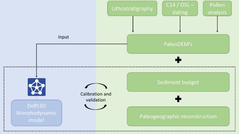
Figure 1: Conceptual framework of the two-sided approach combining paleogeographic reconstruction (right) and morphodynamic models (left).
References
Ronchi, L., Fontana, A., Cohen, K. M., & Stouthamer, E. (2021). Late Quaternary landscape evolution of the buried incised valley of Concordia Sagittaria (Tagliamento River, NE Italy): A reconstruction of incision and transgression. Geomorphology, 373, 107509.