S.G. Pearson1,2, E.P. Elias2, B.C. van Prooijen1, H. van der Vegt2, A. van der Spek2,3, Z.B. Wang2,1
1 Delft University of Technology
2 Deltares
3 Utrecht University
*corresponding author:
Introduction
To adapt the Dutch coast to climate change, a key source of uncertainty lies in the dynamics of the Wadden Island and Sea system. In particular, ebb-tidal deltas form a key component of coastal sediment budgets, exerting a strong influence on adjacent shorelines. Nourishing these deltas has been proposed as a potential solution for maintenance of the Wadden coast, but there is still a need to better describe and quantify the evolution of ebb-tidal deltas. To leverage the availability of high-resolution bathymetric surveys, we propose two approaches for generating new insights into the shoal bypassing process and preservation potential of ebb-tidal deltas.
Methods
The first approach is derive a conformal map of Ameland ebb-tidal delta, placing it in polar coordinates centred at the inlet. Shoals and channels on the delta tend to rotate in a clockwise direction around the inlet, so this approach collapses the morphodynamic behaviour into a timestack for better visualization and analysis. The second approach takes the differences between successive bathymetries to derive a decadal scale (1975-2020) stratigraphic model.
Results
Here we clearly visualize the shoal bypassing process and repeated rotation of channels and shoals around the inlet from updrift to downdrift coasts. Together, these techniques provide new perspectives on ebb-tidal delta dynamics and preservation potential which can be readily applied to other locations with detailed bathymetric data. These findings are useful on short timescales for coastal management (e.g., for planning sand nourishments) but also on much longer timescales (e.g., for interpreting stratigraphy in ancient rock records).
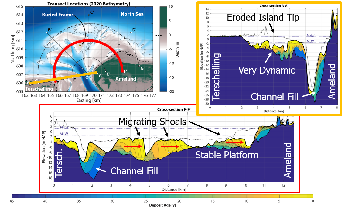
Figure 1: Stratigraphic profiles across Ameland Inlet (A-A') and through the ebb-tidal delta (F-F'). Darker colours represent old deposits, and lighter colours represent more recent deposits.
References
Pearson, S.G., Elias, E.P.L, van Prooijen, B.C., van der Vegt, H., van der Spek, A. & Wang, Z.B. (In review). A Novel Approach to Mapping Ebb-Tidal Delta Morphodynamics and Stratigraphy. Submitted to Geomorphology. [Preprint: https://ssrn.com/abstract=3943525].
I. Surname1*, F.N. Another-Surname2 , Y. Next-Surname2
1 University Name, Country; 2 Organization Name, Country
* Corresponding author: mail.name@organization.org
