B.J.A. Huisman1, D.J.R. Walstra1, M. Radermacher2, M.A. de Schipper3, B.G. Ruessink4
1 Deltares,
2 H-Max,
3 Delft University of Technology,
4 Utrecht University,
Introduction
About 300 kilometers of the sandy Dutch coast is maintained with regular sand nourishments to counteract natural erosion trends, ongoing sea level rise and storm erosion. Large elongated sand nourishments at the seaward side of the sub-tidal bar (i.e. between MSL-4m and MSL-8m; referred to as a 'shoreface nourishment') are the most commonly applied maintenance measures at the Dutch coast. However, the knowledge of their behaviour and underlying driving processes is lacking. In view of sustainable future coastal maintenance, it is very relevant to know where the sand is going to.
Methods
The study uses bathymetric data of 19 shoreface nourishments located at alongshore uniform sections of the Dutch coast (Huisman et al., 2019). Volumetric changes in alongshore and cross-shore sub-regions were used to identify the reshaping. These data were also used to validate an efficient method for predicting the erosion of shoreface nourishments using Xbeach. The model is used to explain the relative contribution of processes rather than act as a prediction model for other nourishments, the good representation of erosion rates (R2 of 0.9) gives confidence in the representation of the considered field cases with a shoreface nourishment.
Results
The considered shoreface nourishments provide a long-term (3 to ~30 years) cross-shore supply of sediment to the beach, but with small impact on the local shoreline shape. Most erosion of the nourishment takes place during energetic wave conditions (Hm0≥3 m) as milder waves are propagated over the nourishment without breaking. Data shows that considerable cross-shore profile change takes place at a shoreface nourishment. Typically, the crest is moving landward, while the crest height remains at about 4 meter water depth. Some accretion can be seen at the shoreline, and a deepening of the trough of up to 2 meter directly landward of the shoreface nourishment. Cross-shore transport contributed 60 to 85% of the losses from the initial nourishment region for the considered cases. This transport was driven partly by water-level setup driven currents (e.g., rip currents) and increased velocity asymmetry of the waves due to the geometrical change at the shoreface nourishment.
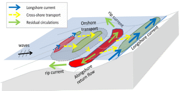
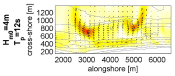
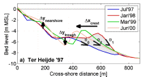
Figure 1 Overview of relevant processes for the redistribution of shoreface nourishments (left panel), an illustration of computed impact of shore-normal storm waves (top-right panel) and an illustration of the measured cross-shore reshaping of a shoreface nourishment at Ter Heijde (lower-right panel).
Reference Huisman B.J.A., Walstra D.J.R., Radermacher M, de Schipper M.A., Ruessink B.G. Observations and Modelling of Shoreface Nourishment Behaviour. Journal of Marine Science and Engineering. 2019; 7(3):59.
I. Surname1*, F.N. Another-Surname2 , Y. Next-Surname2
1 University Name, Country; 2 Organization Name, Country
* Corresponding author: mail.name@organization.org
