
M. van der Lugt1*, E. Quataert1, M. van Ormondt1, A. van Dongeren1,
1 Deltares,
Introduction
The accurate prediction of barrier island response to hurricane forcing is challenging because of the complex interaction of hydro- and morphodynamic processes, such as dune face erosion by wave attack, formation of breaches by wave overwash and inundation, and erosion of channels by return flow from the bay to the ocean. We investigate the sensitivities of barrier island response to Atlantic hurricanes Sandy, Matthew and Florence with a process-based model.
Methods
High-resolution 2D XBeach models were driven with optimally constrained initial and forcing conditions. High-resolution LIDAR topography obtained before and after hurricane Sandy, Matthew and Florence by the USGS provided initial conditions and validation data. Hydrodynamic boundary conditions were generated with a regional D-Flow FM–SWAN computation which was forced with astronomical tides and COAMPS-TC "best track" wind fields. The XBeach models were initialized with spatially varying roughness derived from a supervised conditional-random-field classification of land cover. The model was supplemented with a dynamic roughness module recognizing that, under extreme conditions, vegetation can be washed away or buried by sediment.
Results
The XBeach models showed good agreement with observed erosion volumes and observed crest level lowering. Prescription of spatially varying initial roughness maps and consideration of reduction throughout the storm improved the model skill. This model skill was furthermore sensitive to small variations in offshore wave boundary conditions and storm surge height (all cases), and to back-bay water levels in case an ebb-surge regime prevailed in the tail of the storm. Therefore, forecasts of barrier island impact should be made using an ensemble approach which takes the inherent uncertainty in forcing conditions into account, rather than relying on a single deterministic run.
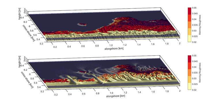
Figure 1 Pre- (top) and modeled post- (bottom) storm barrier island topography for Wilderness Breach – Fire Island (NY-USA) for hurricane Sandy. Color indicates bottom roughness as Manning values. MHW-level in blue for reference.
Reference
van der Lugt, M. A., Quataert, E., van Dongeren, A., van Ormondt, M., & Sherwood, C. R. (2019). Morphodynamic modeling of the response of two barrier islands to Atlantic hurricane forcing. Estuarine, Coastal and Shelf Science, 229, 106404.
I. Surname1*, F.N. Another-Surname2 , Y. Next-Surname2
1 University Name, Country; 2 Organization Name, Country
* Corresponding author: mail.name@organization.org
