Silke Tas1,2*, Zoe Hughes2 , Duncan FitzGerald2, Danghan Xie2, Tansir Zaman Asik2, Sergio Fagherazzi2
1 Wageningen University and Research, the Netherlands; 2 Boston University, USA
* Corresponding author: silke.tas@wur.nl
Introduction
The northwestern Buzzards Bay shoreline in Massachusetts, USA is a complex system consisting of multiple headlands, dividing the coastline into several coastal cells containing tidal inlets and mixed-sediment beaches. While these compartments form (mostly) closed sediment cells during regular wave conditions, high energy events can generate sediment pulses past headlands. As a result, infrequent extreme events, like hurricanes, play a major role in the long-term evolution of this shoreline.
The inlet of Slocums River is situated near the mouth of Buzzards Bay, between the two headlands of Barneys Joy Point and Mishaum Point. The western side of the inlet is characterized by a mixed sand-gravel beach, a sandy spit and a series of beach ridges. Slocums River has been heavily polluted in the past. Although a landfill near Dartmouth, responsible for most of the pollution, has been capped off to prevent polluted run-off into the river (Moraff & United States Environmental Protection Agency, 2019), local communities are worried that further water quality issues may occur as a result of the sediment accumulating near the river inlet. Predicting the future sedimentation around the inlet requires a better understanding of the sources and pathways of sediment transport into Slocums Embayment.
Objective and Methods
This study aims to map pathways and quantify thresholds for headland bypassing around Barneys Joy Point into Slocums River Embayment, using a numerical model (based on Xie et al., in press), and supported by field observations and remote sensing.
Sediment transport in the vicinity of Slocums Embayment is explored using a coupled Delft3D-FLOW/WAVE model. Model boundary conditions are derived from the North Atlantic Coast Comprehensive Study (NACCS), a coastal storm wave and water level modelling study of the US North Atlantic coast (Cialone et al., 2005). Sediment volume changes of the spit at the Slocums River Inlet based on a series LIDAR DEM were used to validate the modelled sediment transport to an order of magnitude.
Results
Slocums Embayment is acting as a sediment sink at the mouth of Buzzards Bay. Based on LIDAR images, the spit near the river inlet is accumulating ca. 2600 m3 sand per year. Under day-to-day conditions, the tidal filling and emptying of Buzzards Bay dominates the current patterns outside of the embayment, and as a result the flow completely bypasses Slocums Embayment. The model results reveal that only under extreme wave conditions (occurring once per year or less) the flow patterns curve around Barneys Joy Point and open a sediment transport pathway into the embayment. The volume of sediment deposited into the
embayment increases with wave height. However, when taking into account the occurrence frequency of the wave conditions, it turns out that the smaller, more frequent extreme wave events (with a return period of one or two years) cumulatively contribute more sediment to the embayment than the most extreme events (return period 10-50 years). While a storm surge can significantly increase the amount of sediment entering Slocums Embayment, the timing between the peak water levels and the peak of the wave conditions can also open a sediment pathway out of the embayment.
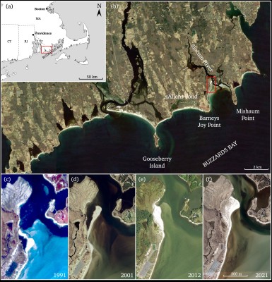
(a) Location of the area of interest in western Buzzards Bay, South Massachusetts, USA. The red rectangle indicates the location of panel b. (b) Slocums Embayment at the mouth of Buzzards Bay, bounded by two headlands: Barneys Joy Point and Mishaum Point. West of Barneys Joy Point is Allens Beach and Allens Pond. The red rectangle indicates the location of panels c-f. (c-f ) Temporal evolution of the spit at Slocums River inlet, in 1991, 2001, 2012 and 2021.
References
Cialone, M. A., Massey, T. C., Anderson, M. E., Grzegorzewski, A. S., Jensen, R. E., Cialone, A., Mark, D. J., Pevey, K. C., Gunkel, B. L., McAlpin, T. O., Nadal-Caraballo, N. C., Melby, J. A., & Ratcliff, J. J. (2005). North Atlantic Coast Comprehensive Study (NACCS) Coastal Storm Model Simulations: Waves and Water Levels (ERDC/CHL TR-15-14, p. 252). U.S. Army Engineer Research and Development Center Coastal and Hydraulics Laboratory.
Moraff, K. & United States Environmental Protection Agency. (2019, October 10). Approval of the Slocums and Little Rivers Embayment System TMDL for Total Nitrogen. https://www.epa.gov/sites/default/files/2019-12/documents/slocums-little-rivers-tmdl-approval-docs.pdf
Xie, D., Hughes, Z., FitzGerald, D., Tas, S., Zaman Asik, T., Fagherazzi, S. (in press). Impacts of Climate Change on Coastal Hydrodynamics Around a Headland and Potential Headland Sediment Bypassing. Geophysical Research Letters, 51, e2023GL105323. https://doi.org/10.1029/2023GL105323
