J. Mi1,2*, T. Gerkema1 , P.W.J.M. Willemsen3,4, J. van der Molen1, J. van de Koppel1,5, M. van de Wegen4,6, T.J. Bouma1,2
1 NIOZ Royal Netherlands Institute for Sea Research, the Netherlands; 2 Utrecht University, the Netherlands; 3 University of Twente, the Netherlands; 4 Deltares, the Netherlands; 5 University of Groningen, the Netherlands; 6 IHE Delft, the Netherlands
* Corresponding author: jie.mi@nioz.nl
Introduction
The Western Scheldt, like many estuaries, faces transitions from natural evolution to artificial adjustments by human interventions. Since the Middle Ages, the latter has caused significant morphodynamic changes; especially continuous land reclamation works and the repeated deepening of navigation channels, remain noticeable today. In the face of present and future sea level rise, there is not only the risk of coastal flooding, but also the possibility of changes in the tidal regime. In this study, we aim to explore the connectivity of historical estuaries, by assessing i) how the morphological changes over time have changed the tidal characteristics, and hence sediment transport; and, ii) the sensitivity of prevailing water levels to dominant wind directions/surges.
Objective and Methods
This study compiles diverse sources of historical geographic and navigation maps, and contemporary measurement data, providing reliable bathymetries for reconstructing tide deformation in ancient configurations of the Western Scheldt. 3D high-resolution numerical simulations will be carried out using the General Estuarine Transport Model (GETM) to simulate the hydrodynamics in the Western Scheldt for each snapshot. We will use the Framework for Aquatic Biological Modeling (FABM) for suspended particulate matter transport, coupled with GETM, which solves the advection-diffusion equation for the total sediment load. By comparing modeled tidal amplitudes with increases in historical dike crest elevations, we attempt to validate the model.
Results
We aim to assess the hypothesized changes by model setup: With the construction of dikes and land reclamation works, the tidal amplitude has likely amplified. Specifically, changes in the asymmetry of the tides will result in changes in the import or export of sediment. In addition, we shall consider the connectivity of historical estuaries and their impact on the freshwater distribution, and on estuarine circulation and sediment transport.
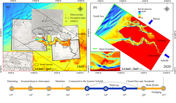
Figure 1. Timeline of Western Scheldt and: (a) Maps of 1860, integrate with navigation maps, measured data, and General Bathymetric Chart of the Oceans (GEBCO); (b) Grid of GETM, 2020.
