Ü.S.N.Best 1*, L. Bratt 1, A. Joling 1
1 Royal HaskoningDHV, The Netherlands
* Corresponding author: uwe.best@rhdhv.com
Introduction
Small Island Developing States (SIDS) face exceptional challenges due to their size, topography, and vulnerability to climate change driven impacts. These vulnerabilities necessitate innovative and sustainable nature-driven approaches to build resilience. Despite the economic, environmental, and social benefits they generate, investments in Nature-based solutions (NbS) projects remain limited: with a projected global financing gap exceeding $700 billion. The closure of this financing gap requires not only public financing and philanthropic funds, but it is imperative to attract private investors. Together with Van Oord, WWF Netherlands, Rabobank, SIWI, EcoShape and Conservation International- we utilize larger landscape plans of NbS investment options comprising both green and grey solutions to provide a strategic overview of project groupings.
Objective and Methods
We have utilized a cutting-edge approach—a Landscape Mapping Tool designed to enhance the understanding, planning, and financing of nature-based projects. With a focus on the SIDS region, we developed a Bonaire case study. This tool combines geospatial data, hazard vulnerability and ecological assessments, and financial overview to provide a holistic view of the potential impact and cost-effectiveness of NbS interventions. The hazard drive approach, which enhances our understanding of the baseline and future challenges for Bonaire, includes aspects such as sea-level rise and increasing of the (water) temperature and acidity, pluvial and fluvial flooding, storm surges and extreme wind, landslides, and anthropogenic influences. This interactive, web tool contains layers for population density, elevation and bathymetry, land use and inundation, which provide additional contextual data.
Results
The risk assessment layer identifies the direct and indirect damage relationships to quantify climate risk for each relevant hazard. For all hazard-asset combinations, direct damages were measured by vulnerability curves. The potential impacts and problems arising are mapped in full detail corresponding to the unique hazard, and this provides the basis for the nature based (green and grey) solutions for the island. Additional details relating to the bankability and funding sources are captured within the tool. The blended financing possibilities for sustainable projects are structured through green bonds /PP / loans, social bonds / PP / loans, and sustainable bonds / PP / loans.
This tool provides potential benefits towards closing the financial gap through enhanced stakeholder communication regarding natural capital solutions and specific financing strategies.
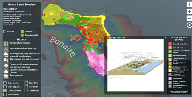
Interface for Bonaire Landscape Mapping Tool: Hazard assessment, solutions and bankability.
References
Colleen B. Bove, L. M. (2022). A century of warming on Caribbean reefs. Plos Clim. Retrieved from https://journals.plos.org/climate/article?id=10.1371/journal.pclm.0000002
EcoShape. (2021). Paving the way for scaling up investment in nature-based solutions along coasts and rivers. Retrieved from https://www.ecoshape.org/app/uploads/sites/2/2021/05/White-paper-Paving-the-way-for-scaling-up-nature-based-solutions.pdf
Matthijs van der Geest, E. M. (2020). Impact of terrestrial erosion on coral reef health at Bonaire: a plea for nature-inclusive “watershed-to-reef” based coastal management. Wageningen: Wageningen University & Research. Retrieved from https://www.dcbd.nl/sites/default/files/documents/impact_of_terrestrial_erosion_on_coral_reef_healt-wageningen_university_and_research_524688.pdf
Mücher, C. /. (2017). Elevation Bonaire. Retrieved from https://www.dcbd.nl/document/improved-aster-elevation-model-bonaire
Mücher, C. /. (2020). Land use map of Bonaire. Wageningen University & Research, Wageningen. Retrieved from https://www.dcbd.nl/document/land-use-map-bonaire
Pieter van Beukering, L. v. (2022). The Impacts of Climate Change on Bonaire. VU Amsterdam. Amsterdam: Institute for Environmental Studies. Retrieved from https://assets.vu.nl/d8b6f1f5-816c-005b-1dc1-e363dd7ce9a5/0973b67e-3084-4590-9a76-fa123436d113/IVM_R22-06_Synthesis%20Report%202022.pdf
Verweij, P. /.-W. (2020). Landscape map Bonaire. Wageningen University & Research, Wageningen. Retrieved from https://www.dcbd.nl/document/landscape-map-bonaire
WWF. (2020). Bankable nature solutions. WWF Bankable Blueprint Book. Retrieved from https://wwfint.awsassets.panda.org/downloads/bankable_nature_solutions_2__1.pdf
