A. Kroon1,2*, L. Spaans1 , B. van Leeuwen1, Y. Attema1 and K. van der Giessen3
1 Svašek Hydraulics, The Netherlands; 2 Delft University of Technology, The Netherlands; 3 Wetterskyp Fryslân, The Netherlands
* Corresponding author: kroon@svasek.com
Introduction
Developed barrier islands are likely to drown due to anthropogenic activities that reduce overwash delivery and the landward extent of overwash (Rogers et al., 2015). On the Dutch barrier islands sand-drift dike development has been common in recent decades. The practice has reduced sediment mobility and overwash delivery (Oost et al., 2012). The resulting accelerated succession of vegetation in the hinter-lying salt marsh prevents the supply of fines from the back-barrier basin and finally leads to a relative deepening of the barrier island (Bakker et al., 2023).
Coastal managers' awareness of these issues is rapidly increasing, and (partial) removal of the sand-drift dikes is under consideration at multiple locations. One example is the Dutch barrier island Schiermonnikoog, where the inundation risk is higher than allowed according to Dutch standards. The drafting of reinforcement plans started in 2022. These plans aim to enhance the long-term resilience of the island, and may entail the (partial) removal of the sand-drift dike to create dune notches or an overwash complex.
Whether such activities can lead to the desired increase in sediment dynamics will depend on the ambient morphological trend (Arens, 2022), with higher dynamics observed at eroding coasts.
Objective and Methods
This study aims to map the morphological trend of the North Sea coast of Schiermonnikoog to assess the feasibility of stimulating the dynamics and resilience of the island against sea level rise. To this end we analyzed dune volume, beach width and shoreline position trends using the Jarkus Analysis Toolbox (Van IJzendoorn, 2021). These trends are given a physical context using a visual cross-shore analysis.
The trends are analyzed in three sections. These sections are respectively from west to east: 1) the head of the island "Eilandkop", which is most significantly affected by the behaviour of the ebb-delta; 2) the "Oosterduinen", a natural dune system with multiple dune rows with a Northern orientation and 3) the most eastern section, the sand-drift dike "Stuifdijk".
Results
The morphological development on Schiermonnikoog is dominated by the periodic landing and spreading of large volumes of sand from the ebb-delta. During the last landing of a sand bar from the ebb-delta (1990s), the beach width significantly increased, and a green beach formed on Schiermonnikoog. The vegetation on the green beach captures sediment and thus prevents further aeolian transport to the dunes, Fig. 1. Especially at the Eilandkop, the beach is too wide for marine processes affecting the dunes, and the dynamics are low. The start of a new landing of sand from the ebb-delta is can be observed at the Oosterduinen, which is will probably increase the beach width especially at the Eilandkop before dynamics can start to increase.
Therefore, the chances of increasing dynamics seem to be highest for the Stuifdijk. A recent eroding trend in volume and beach width is observed. Parts of the embryonic dunes and the green beach have eroded. Continuation of this trend will naturally increase dynamics in the first dune rows or beyond. Therefore, acceleration of this process by constructing a notch or a washover at this location is under considation. Hopefully, this will increase the islands' resilience to rising sea levels.
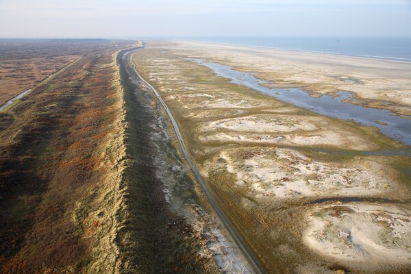
Figure 1: Aerial image of Schiermonnikoog with from left to right the salt marsh, the sand-drift-dike, the green beach, the sandy beach and the North sea (source: Beeldbank Rijkswaterstaat, Joop den Houdt).
References
Arens, B., Bos, B., Damsma, P., Geelen, L., Goessen, P., Graaf, S. van der, Groenendijk, D., Harkema, E., Heide, T. van der, IJff, S., Janssen, M., Kooijman, A., Lamers, J., Meij, T. de, Meijer, J., Nachbar, N., Nijenhuis, M., Oost, A., Prins, M., Roeland, E., Rossenaar, A.-J., Smit, G.-J., Spek, E. van der, Terlouw, S., Valk, B. van der, Wijk, K. van, Zijlstra, A. (2022). Handleiding Dynamisering Zeereep, Versie 1.0.
Bakker, Berg, Grootjans, Olff, Schrama, Reijers, Van der Heide, (2023). Biogeomorphological aspects of a model barrier island and its surroundings - Interactions between abiotic conditions and biota shaping the tidal and terrestrial landscape: A synthesis, Ocean & Coastal Management, 239, 106624.
Oost, Hoekstra, Wiersma, Flemming, Lammerts, Pejrup, Hofstede, van der Valk, Kiden, Bartholdy, van der Berg, Vos, de Vries, Wang, (2012). Barrier island management: Lessons from the past and directions for the future, Ocean & Coastal Management, 68, 2012, 18-38.
Rogers, Moore, Goldstein, Hein, Lorenzo-Trueba, and Ashton (2015). Anthropogenic controls on overwash deposition: Evidence and consequences, J. Geophys. Res. Earth Surf., 120, 2609–2624.
Van IJzendoorn, (2021). Jarkus Analysis Toolbox, https://github.com/christavanijzendoorn/JAT
