A.M. Ton1*, T. Van Kessel1 , J. Kollen2, R. Noordhuis1, J. de Leeuw3, M.S. van den Berg4,5, Q. Smeele6, K. Kaffener7
1 Deltares, The Netherlands; 2 Sweco, The Netherlands, 3 Wageningen Marine Research, 4 Rijkswaterstaat, The Netherlands, 5 Aeres Hogeschool, The Netherlands, 6 Natuurmonumenten, The Netherlands, 7 Ministry of Infrastructure and Water Management, The Netherlands
* Corresponding author: Anne.Ton@Deltares.nl
Introduction
Well-functioning, natural, lowland freshwater lakes commonly possess elements such as gradual land-water transitions, heterogeneity in water depths or water-level fluctuations (Schindler et al., 2002). The traditional engineering structures and artificial water level control present in lake Markermeer oppose these elements. To enhance the ecological integrity of lake Markermeer, an archipelago of shallow marsh islands, called Marker Wadden, was constructed between 2016 and 2018 to add the structure and dynamics that are more typical for a natural freshwater lake, while maintaining the lake’s current ecosystem services (Van Leeuwen et al., 2021).
Research results from KIMA 1.0 (Knowledge and Innovation program Marker Wadden, 2017-2022*) show that the new ecosystem is still developing and that the islands are being shaped by waves, currents and consolidation. It is yet to be confirmed that the Marker Wadden contribute or moreover lead to a robust and climate adaptive lake Markermeer.
The use of mud is an important building block for maintenance of the islands and the long term stability of the reed marsh. When the fines are harvested in the right places this contributes to the water quality around the islands and collecting and relocating them can be part of maintenance of consolidating islands.
Objective and Methods
The objective of KIMA 2.0 (2023-2026) is to research what is needed for futureproof islands that have a positive impact on water quality and productivity in lake Markermeer. We focus on mud and food flows between and around the Marker Wadden and the interaction between ecological processes.
The project leads to an action perspective for acceleration of natural mud accretion in the compartments and lee areas. Moreover, a feasibility study on slow dredging and deposition to further accelerate mud accretion will show the potential for sustainable maintenance of the islands. We will quantify the supply and sedimentation of the mud as a function of flow and wave conditions and the extent of the local reed marsh.
To gain insight into the mud flows, field monitoring is needed. This is a combination of bathymetric surveys, sediment sampling and measurements of currents and waves, which is planned for 2024 and 2025. With the field data, a numerical model is validated and the impact of the design of the islands on capturing mud is analyzed. Parallel, a feasibility study on small-scale, sustainable, “slow” dredging is executed.
Results
The islands or compartments consist of sandy ring dikes, filled with mud. After several rounds of addition of a muddy layer, consolidation and ripening the islands submerged. Most islands are now in open connection to lake Markermeer. Earlier research shows that the sand mining pits around the islands and the lee areas near the islands capture mud, positively affecting the local mud balance and turbidity. We expect to quantify this effect further, with a focus on the flows between and around the islands. Ideally, we will be able to predict whether an equilibrium between consolidation and inflow of sediment is possible in the future and advise on maintenance or even design of new islands to ensure this equilibrium.
Results already show that the concept of “slow dredging” to increase mud flows towards the islands is technically feasible. This zero-emission and vegetation friendly technique is promising, and inquiry into a possible pilot study is ongoing.
The results on mud flows will be combined with research on food and nutrient flows, to result in guidance towards a robust and climate adaptive reed marsh with a variation in biotopes facilitating birds and fish.
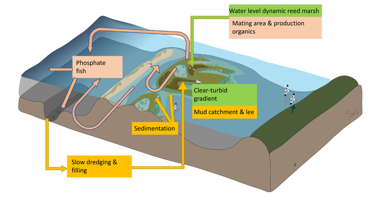
Transport of nutrients and fish (pink), mud management and maintenance islands (orange) and water level dynamics and formation reed marsh (green). (Illustration by Suzanne van Donk)
References
*https://waterinfo-extra.rws.nl/projecten/lijst-projecten/kennis-marker-wadden/kennis-innovatieprogramma-marker-wadden/final-results/
Schindler, D. E., & Scheuerell, M. D. (2002). Habitat coupling in lake ecosystems. Oikos, 98(2), 177–189.
Van Leeuwen, C. H., Temmink, R. J., Jin, H., Kahlert, Y., Robroek, B. J., Berg, M. P.,Lamers, L. P., Van den Akker, M., Posthoorn, R., Boosten, A., Olff, H.,
& Bakker, E. S. (2021). Enhancing ecological integrity while preserving ecosystem services: Constructing soft-sediment islands in a shallow lake.
Ecological Solutions and Evidence, 2(3), 1–10.
