C.D. Bhoobun1*, F. Grasso1, R. Verney1
1 IFREMER : French national institute for ocean science and technology, France
* cbhoobun@ifremer.fr
Introduction
Intertidal mudflats are coastal wetlands located between high and low tides, providing essential habitat, storing sediments, and offering natural coastal protection. These systems are increasingly threatened by global change, including sea-level rise, altered sediment supply, and human activities, motivating interest in their future evolution. Tidal creek networks, often present in these mudflat systems, are key features that serve as major pathways for water and sediment exchange and influencing mudflat morphology, sediment dynamics, and nutrient cycling (Hanssen et al., 2022; Glasser et al., 2021). Both mudflats and tidal creeks have been extensively studied independently through field observations and numerical models. However, many existing morphodynamic models rely on two-dimensional cross-shore representations, which often neglect tidal creek presence and dynamics, thereby limiting their ability to capture coupled mudflat-creek evolution (Coco et al., 2013). This study explores the hydro-morpho-sedimentary evolution of intertidal flats while accounting for tidal creek formation. By integrating these multi-scale morphological structures into a schematic modelling framework, this study aims to investigate how mudflats may evolve over time.
Objective and Methods
To explore the coupled evolution of intertidal flats and tidal creeks, numerical simulations are performed using CROCO–MUSTANG, a coupled modelling system in which CROCO resolves hydrodynamics and MUSTANG (Le Hir et al., 2011) computes sediment transport and bed evolution. Creeks are initiated by introducing small topographic perturbations (<1 cm, randomly distributed) into an initially smooth bathymetry. This approach follows studies showing creeks develop in micro-depressions that focus flow, enhance local erosion, and enable natural creek formation (Whitehouse et al., 2000). A 500x1500-m domain with 5-m grid resolution, an 8-m tidal range, and cohesive (mud-only) sediment were used to simulate morphological evolution of mudflats over a 20-year period. The model does not intend to be site-specific, but capture realistic morphodynamic behaviour under comparable forcings. Model validation is performed using COSMOS (Characterisation Of bed Structure MOrphologies and Spacing), a tool developed to compare structural features of creeks (depth and width) between simulations and observations. Idealised simulations are explored to investigate intertidal mudflat typologies and assess how upper flat geometry (length, slope, elevation relative to mean sea level) and tidal range (from micro- to macro-tidal conditions) influence creek development and mudflat evolution.
Results
The validation phase confirmed that the model reproduces realistic creek morphologies. Using COSMOS, simulated creek depths, widths, and width-to-depth ratios were compared with in-situ measurements from a large mudflat in the Seine Estuary (France). Similar comparison patterns show the model captures key creek network characteristics. Typology simulations were conducted on a 1000-m-long upper flat with an 8-m tidal range, using the same micro-topographic perturbations. Varying the slope (0.1, 0.25, 1, 1.5, and 2 ‰) produced distinct creek patterns, indicating creek formation in the model was strongly influenced by bed slope. A very gentle slope (0.1 ‰) formed a large and deep creek, while a slope of 0.25 ‰ produced multiple shallower creeks. At an intermediate slope of 1‰, creek development was limited to a few creeks, whereas a slope of 1.5 ‰ produced one main creek. At a slope of 2 ‰, creek was negligible (<10 cm), suggesting a threshold beyond which creek development is limited. These observations show that creeks density and complexity varied across slopes, without following a monotonous linear trend. Cross-shore bed profiles show that lower slopes experience greater morphological change in 20 years, highlighting the control of initial flat geometry on long-term mudflat evolution. This opens perspectives for studying mudflat typologies and creek networks under varying slopes, tidal ranges, sediments, and bed geometries.
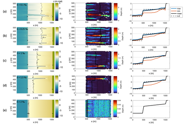
Figure 1: Model simulations for different initial slopes, s = 0.1, 0.25, 1, 1.5, 2 ‰ (a–e) on a 1000-m-long upper flat with an 8-m tidal range. From left to right, the first panel shows model output at t = 20 years, the second panel shows COSMOS output with detected creeks’ depths, and the third panel shows cross-shore bed profiles with initial (t = 0) and final (t = 20 years) elevations (minimum, mean, and maximum) profiles.
References
Coco, G., Zhou, Z., Van Maanen, B., Olabarrieta, M., Tinoco, R. and Townend, I., 2013. Morphodynamics of tidal networks: Advances and challenges. Marine Geology, 346, pp.1-16.
Glaser, C., Frei, S., Massmann, G. and Gilfedder, B.S., 2021. Tidal creeks as hot-spots for hydrological exchange in a coastal landscape. Journal of Hydrology, 597, p.126158.
Hanssen, J.L.J., van Prooijen, B.C., Volp, N.D., de Vet, P.L.M. and Herman, P.M.J., 2022. Where and why do creeks evolve on fringing and bare tidal flats?. Geomorphology, 403, p.108182.
Le Hir, P., Cayocca, F. and Waeles, B., 2011. Dynamics of sand and mud mixtures: A multiprocess-based modelling strategy. Continental Shelf Research, 31(10), pp.S135-S149.
Whitehouse, R.J.S., Bassoullet, P., Dyer, K.R., Mitchener, H.J. and Roberts, W., 2000. The influence of bedforms on flow and sediment transport over intertidal mudflats. Continental Shelf Research, 20(10-11), pp.1099-1124.
