V. Basnayake 1*, T.M. Duong 1,2, R. Ranasinghe 1,2,3, R. Almar4, K.M. Wijnberg1 and S. J. M. H. Hulscher1
1Department of Civil Engineering and Management, University of Twente, Enschede, The Netherlands
2Department of Coastal and Urban Risk & Resilience, IHE Delft Institute for Water Education, Delft, The Netherlands
3Deltares, Delft, The Netherlands
4Laboratoire d'Etudes en Géophysique et Océanographie Spatiales (LEGOS), Toulouse, France
* Vindhya Basnayake: b.m.v.basnayake@utwente.nl
Introduction
Coastal environments are among the most valuable and dynamic regions on Earth, supporting diverse ecosystems, high biological productivity, and socioeconomic activities. However, these coastal regions are increasingly exposed to hazards such as coastal flooding and erosion. The risks caused by these hazards depend not only on the level of hazards but also on the vulnerability of the exposed coastal environments. Therefore, in prioritizing the adaptation efforts, it is important to have a robust understanding of the coastal vulnerability to flooding and erosion. The Coastal Vulnerability Index (CVI) is the most widely used approach for assessing coastal vulnerability, integrating multiple geophysical indicators into a single relative measure of vulnerability. While CVI assessments have been extensively applied at local and regional scales, methodological differences and limited data availability have constrained the development of consistent global-scale analysis, which is important for informing the macro-scale decisions. By employing currently available global datasets together with the widely used Coastal Vulnerability Index (CVI) approach, this study assesses present-day coastal vulnerability at the global scale and analyses the vulnerabilities at country, IPCC AR6 region level and for different coastal typologies. Further, contribution of each indicator to the CVI is calculated to understand the dominant indicators in CVI.
Objective and Methods
To calculate the CVI at the global coast, four CVI methods (i.e., methods suggested by López et al. (2016); E. R. Thieler & Hammar-Klose (2000); Shaw et al. (1998); Gornitz (1991)) were selected, which were commonly used in the literature. The CVI aggregates multiple geophysical and coastal forcing indicators (including: Coastal slope/relief, geology, geomorphology, wave height, relative sea level change rate, mean tidal range, and shoreline change rate) to determine the vulnerability of coastal environments. Openly available global coastal datasets were used for extracting the data for each indicator at 363,424 sampling locations spread over the global coastline. The selected methods use a similar approach in calculating CVI, although the indicators used and the method of assigning the vulnerability rankings differ from one method to another (for more details refer to (Koroglu et al., 2019)). Selected indicators are ranked using a ranking system of 1-5, where 1 is assigned for the least vulnerability, and 5 is assigned for the highest vulnerability. The overall CVI value at a sampling location was calculated by aggregating the ranks for the selected indicators, by taking the square root of the product mean of vulnerability ranks.
In each method, calculated vulnerability index values were classified into five equal-sized vulnerability classes from Very Low to Very High vulnerability. Value ranges for each vulnerability class were decided based on the percentile ranges (i.e., the Lowest 20% of the locations were classified as ‘Very Low’ etc.). Globally computed CVIs using the mentioned four methods were compared with higher resolution local and regional CVI assessments to identify the optimal method for a global scale assessment. The CVI method thus identified was then adopted to assess present-day coastal vulnerability at country and IPCC AR6 region level, and also for different coastal typologies. This aggregation was done by taking the median CVI class for each country, IPCC region level and for typologies, which were calculated by taking the median CVI value of all the points located along a country’s/IPCC region’s coastline, and for each typology, and then classifying them into the CVI classes (from ‘Very Low’ to ‘Very High’).
Results
Comparison of the pointwise CVIs calculated using the four methods, with the previously published CVI studies, shows that the methods suggested by López et al. (2016), are more suitable for the global scale application. Therefore, further analyses were carried out using this method. Figure 1 shows the median CVI classes calculated at the country and IPCC region level. The country level assessment shows that Aruba, Benin, Togo, Democratic Republic of the Congo, Bonaire, Sint Eustatius and Saba, Sri Lanka, Nigeria, French Guiana, Ghana and Liberia have the highest median coastal vulnerability at present. However, it should be noted that due to constraints in the available input data, many small islands (e.g., those in the Caribbean and Pacific) have been excluded from this analysis. At the IPCC AR6 region scale, Central North America, and Northern South America emerge as the regions with the highest median coastal vulnerability. Both country level and IPCC region level assessments indicate that tropical and subtropical regions are more vulnerable to coastal hazards than other parts of the world. Typologically, large rivers, arheic, and lagoons are the typologies with the highest level of coastal vulnerability, while fjords and fjaerds are the least vulnerable coastal typologies. Analysis of the relative contributions of the different indicators to the country level CVIs indicates that geomorphology, mean tidal range, and coastal slope are the dominant contributors to the CVI in countries with High to Very High median CVIs (Basnayake et al., 2026). Since coastal vulnerability is influenced by climate change impacts, our future research will focus on how coastal vulnerability may evolve under different climate change scenarios.
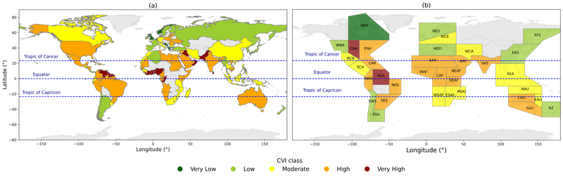
Median CVI classes calculated at the (a) country level, (b) IPCC AR6 region level.
References
Basnayake, V., Duong, T. M., Ranasinghe, R., Almar, R., & Wijnberg, K. M. (2026). A global assessment of coastal vulnerability and dominant contributors. Nature Communications, 17(1), 578. https://doi.org/10.1038/s41467-025-67275-6
E. R. Thieler, & Hammar-Klose, E. S. (2000). National Assessment of Coastal Vulnerability to Sea-Level Rise: Preliminary Results for the U.S. Atlantic Coast. In U.S. Geological Survey Open-File Report 99-593. https://doi.org/10.3133/ofr00178
Gornitz, V. (1991). Global coastal hazards from future sea level rise. Palaeogeography, Palaeoclimatology, Palaeoecology, 89(4), 379–398. https://doi.org/10.1016/0031-0182(91)90173-O
Koroglu, A., Ranasinghe, R., Jiménez, J. A., & Dastgheib, A. (2019). Comparison of Coastal Vulnerability Index applications for Barcelona Province. Ocean and Coastal Management, 178. https://doi.org/10.1016/j.ocecoaman.2019.05.001
López, R. M., Ranasinghe, R., & Jiménez, J. A. (2016). A Rapid, Low-Cost Approach to Coastal Vulnerability Assessment at a National Level. Journal of Coastal Research, 32(4), 932–945. https://doi.org/10.2112/JCOASTRES-D-14-00217.1
Shaw, J., Taylor, R. B., Forbes, D. L., Ruz, M.-H., & Solomon, S. (1998). Sensitivity of the coasts of Canada to sea-level rise (pp. 1–79.).
