R.L. de Swart1*, K. van der Laan1 , L.M. Perk1
1 WaterProof Marine Consultancy & Services, the Netherlands
* Corresponding author: rinse.deswart@waterproofbv.nl
Introduction
In 2019-2020, the Borssele export cables have been installed to connect the Borssele offshore wind farm with the electricity grid onshore at Vlissingen. These cables cross the Spijkerplaat, a highly dynamic sandy shoal that is located in the Western Scheldt in front of Vlissingen (see Figure 1). To protect other sea users against the cables and to protect the cables against external threats (dragging anchors or fishing gear), minimum cover requirements have been set by Rijkswaterstaat in the Waterwet permit. In order to monitor the coverage above the export cables, detailed bathymetric surveys are conducted twice a year since completion of the cable installation. Analysis of these surveys has revealed that the coverage along specific cable sections on the Spijkerplaat decreases by several meters per year, meaning that compliance with the permit requirements will be compromised if this erosion rate continues. To decide whether mitigating measures like sand nourishments or cable reburial are necessary, WaterProof conducted a detailed study to analyse the morphological evolution of the Spijkerplaat.
Objective and Methods
In the present study, the historic morphological evolution of the Spijkerplaat has been analysed. The resulting findings have been used to provide an outlook for the expected morphological development of the Spijkerplaat in the near future. To this end, large-scale bathymetric surveys with a resolution of 20 m (generally available every year) were obtained from the Vaklodingen database of Rijkswaterstaat for the period 1970-present. These surveys were examined to determine the morphological trends through time. Based on the findings of these analyses, a prediction was made regarding the expected future trends in bed level evolution and its impact on the coverage of the Borssele export cables.
Results
Based on the analysis of the historic bathymetric surveys, it can be concluded that the Spijkerplaat is highly dynamic and seems to be characterized by a cyclical movement of tidal channels and sandy shoals with a period of 30-35 years. In at least two of these cycles (1970-2000 and 2000-present), a channel forms south of the Spijkerplaat (the Schaar van de Spijkerplaat) that subsequently migrates towards the north/northeast in subsequent years. This causes a redistribution of the sediment that makes up the Spijkerplaat and, when the channel migrates over the cables, may result in a significant decrease in cover above the cables. It is expected that this process will continue in the coming years and that coverage above the cables will continue to decrease. It is likely that the coverage at the Spijkerplaat will no longer comply with the permit requirement from 2025/2026 onward (starting between kilometric point – KP 3.7-3.8). Because the dynamics of the Spijkerplaat have a cyclical character, the coverage above the cables will eventually increase again. However, it is currently difficult to estimate when this will be the case.
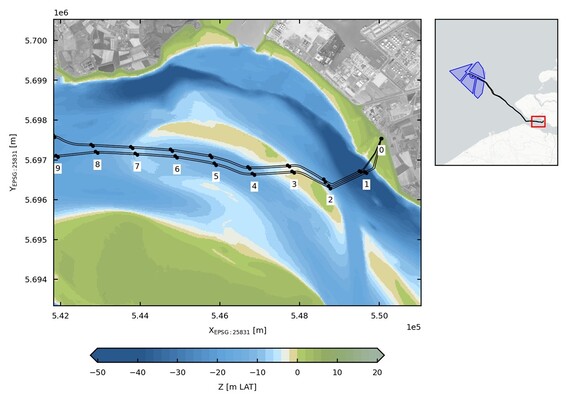
Figure 1: Location of the Borssele cables. The left panel shows the cable locations around the Spijkerplaat (including KP – kilometric point numbering), with as background the vaklodingen bathymetry from 2021 (m LAT). The right panel shows the complete cable routes and the Borssele windfarm area (the Spijkerplaat area is located in the red rectangle).
