Dutta1*, Middelkoop1 , Ruessink1 on behalf of the entire Delta-ENIGMA consortium (UU,TUD,UT, WUR, NIOZ, Deltares, TNO-GDN)
1Faculty of Geosciences, Utrecht University
* Corresponding author: s.dutta1@uu.nl
Introduction
Deltas and coastal plains are among the most dynamic and productive landscapes on Earth, shaped by the continuous interaction between physical and biological processes. This interplay has built and continuously reshaped the Dutch delta across spatial and temporal scales. However, deltas worldwide are facing growing risks from climate change, sea-level rise, land subsidence, and intense human intervention. Understanding how biological and physical processes interact is therefore crucial to predicting delta resilience, identifying potential tipping points, and developing effective adaptation strategies.
Delta systems evolve through coupled bio-physical interactions operating under both everyday conditions and extreme events, such as floods, storms, and droughts. However, these interactions remain insufficiently quantified at the scale of entire deltas, particularly during extreme events, due to limited long-term and integrated observations. And that is where Delta-ENIGMA comes in. Delta-ENIGMA is a 10-year NWO-funded Large Scale Research Infrastructure (LSRI) project, in which a consortium of seven Dutch institutions of NCK and NCR closely collaborate. Delta-ENIGMA aims to address this gap by establishing an observation network across rivers, estuaries, and beach-dune systems. By combining state-of-the-art monitoring technologies with long-term measurements, it advances biogeomorphology research and positions the Dutch delta as a unique Super Site for capturing both gradual change and sudden disruptions.
Objective and Methods
Central to this effort is the deployment of state-of-the-art field instrumentation, including high-resolution 3D laser scanners, multibeam echosounders, submerged flow and sediment sensors, wave recorders, and multispectral drones. These measurements are complemented by targeted monitoring during extreme events, capturing high-impact processes that strongly influence long-term delta evolution. Delta-ENIGMA also upgrades and develops laboratory facilities such as a wind tunnel, mesocosm systems, and advanced bio-morphodynamic flumes to experimentally investigate processes that are difficult to observe directly in the field but critical for future climate scenarios.
To maximize scientific and societal impact, Delta-ENIGMA integrates its observational and experimental facilities within an open, federated data infrastructure and a knowledge interaction platform. An open source software package will enable data from all instruments to be read, quality controlled, documented with standardized metadata, structured in consistent formats, and uploaded to centralized storage.
Together, these facilities provide researchers and policymakers with unprecedented access to high-quality data, experimental capabilities, and collaborative environments. By linking fundamental biogeomorphological understanding to applied research and innovation, Delta-ENIGMA strengthens the Dutch delta’s role as an international super site for advancing climate adaptation and sustainable delta management.
Results
In the last 2 years, Delta-ENIGMA successfully achieved several keys tasks and objectives. Effective collaboration among partners and open communication facilitated the integration of expert knowledge. Locations for observation and measurements are finalized. They are as follows:
- River: Rotterdam, Hoek van Holland and Afferdense en Deestse Waarden
- Estuary: Zuidgors and Waarden, both in the Western Scheldt
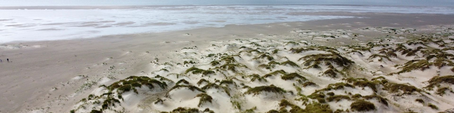
- Beaches and dunes: Sand Motor (nourishment), Egmond aan Zee (recreational beach) and Castricum (dynamic dune management)
Besides that, the appropriate equipment for storm events and extreme conditions, e.g. AQUADOPP, turbidity logger, ADCP’s, wave recorders, multispectral drone etc. are acquired. Various teams, involving MSc students, are being set-up to go out into the field when an extreme event is imminent.
Laboratory facilities made progress with equipment procurement and with the designing of wind tunnel, mesocosm lab and the complex BioLiveFlumes lab.
Productive knowledge interaction facility successfully designed the roadmap for 4 labs (IDlab-Deltares, Wanderlab-WUR, Serious Gaming Lab- TUD and the Design Lab- UT).
ICT designed a roadmap for the data management infrastructure. iRODS in combination with Yoda is chosen for the federated data environment.
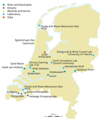
Locations across the map of Netherlands consisting field measurements, laboratory facilities, productive knowledge interaction facility (PROD) and open database
