C.C.P.M. van Oijen1*, J. Sun2 A. Ismanto3 , A.J.H.M. Reniers2 and S.A.J. Tas1
1 Wageningen University and Research, The Netherlands; 2 Delft University of Technology, The Netherlands; 3 Universitas Diponegoro, Indonesia
* Corresponding author: carlo.vanoijen@wur.nl
Introduction
Coastal regions are home to almost 40% of the global population and morphologically dynamic environments shaped by natural and anthropogenic processes. Climate change alters hydrodynamics, which together with human activity influences sediment supply and transport. Mangrove forests bring stability to shorelines, but due to human activity, mangrove forest area decreased, leading to heavy coastal erosion (Richards and Friess, 2016; Hamilton, 2013; Mazda et al., 2002).
In Demak, Indonesia, the presence of a chenier, creates favorable conditions for mangrove reforestation and thus counters coastal erosion. A chenier is a sand bar, formed on a muddy coast, which reduces hydrodynamic stresses and stabilizes the mudflat behind it, improving the window of opportunity for mangrove forests (van Bijsterveldt et al., 2023). Cheniers thus might have great potential as a Nature-based Solution (NbS) enhancing mangrove reforestation.
Tas et al. (2022) developed an idealized morphodynamic model of cross-shore chenier migration. While this model is well validated for onshore migration, the drivers of offshore migration remain less supported by field observations. Validating the model with more detailed field observations can improve process understanding and therefore the assessment of the cheniers' potential as a Nature-based Solution.
Objective and Methods
The aim of this research is to improve the understanding of chenier morphodynamics in the context of Nature-based Solutions for mangrove reforestation. This will be done measuring hydrodynamic drivers in relation to cross-shore chenier dynamics. Tas et al. (2022) hypothesized that a tidal phase lag generated on the mangrove-side of the chenier may influence cross-shore sediment transport. This hypothesis was tested through fieldwork on a chenier in Demak in December 2025, measuring water levels and bed level changes on and around the chenier.
Bed level changes were measured by installing erosion pins along five transects (EPTs) across two cheniers. All pins were initially placed with an exposed length of 0.5 meters above the chenier surface. Regular measurements were used to determine the elevation change of the chenier surface.
In total, 12 pressure sensors were deployed to measure water levels around the cheniers. They were distributed over the surf zone on the seaward side of the cheniers, and the mudflat and mangrove forest on the landward side of the cheniers. For sensors that were only partially submerged during the tidal cycle, a harmonic tidal analysis (using UTide, Codiga, 2011) was used to reconstruct the full tidal cycle.
Results
EPT1 to 3 showed clear landward migration patterns, substantiated with an accretion on the mudflat of 0.35 meters at the edge of EPT1, while EPT2 and 3 showed accretion of around 0.2 meters. Erosion takes place mostly in the region seaward, close to the chenier crest, while a second accretion zone is found seaward of this erosive zone. Along EPT4 the chenier also migrated landward, where accretion took place until the mangrove edge. Most of the erosion, however, took place not in front of the chenier crest, but around a bar in front of the chenier. EPT 5 also showed landward migration and erosion in front of the crest. However, on the last day of measurements a lot of accretion occurred here.
The water level time series measured by the pressure sensors reveal local differences in the tidal dynamics. The reproduction of the tidal signal provides opportunities for phase lag quantification.
Water level gradients across the chenier (caused by the tidal phase lag on the mangrove side of the chenier) can then be linked to the morphodynamic response of the chenier, measured along the erosion pin transects.
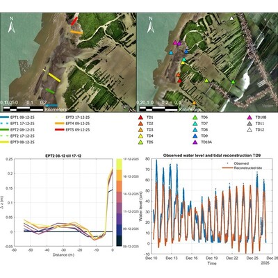
Erosion pin transects (top left panel), relative bed level changes of the chenier along an EPT (bottom left panel), distribution of pressure sensors (top right panel) and tidal reconstruction of one pressure sensors' output (bottom right panel).
References
Codiga, D. L. (2011). Unified tidal analysis and prediction using the UTide Matlab functions.
Hamilton, S. (2013). Assessing the Role of Commercial Aquaculture in Displacing Mangrove Forest. Bulletin of Marine Science, 89(2):585–601.
Mazda, Y., Magi, M., Nanao, H., Kogo, M., Miyagi, T., Kanazawa, N., and Kobashi, D. (2002). Coastal erosion due to long-term human impact on mangrove forests. Wetlands Ecology and Management, 10(1):1– 9.
Richards, D. R. and Friess, D. A. (2016). Rates and drivers of mangrove deforestation in Southeast Asia, 2000–2012. Proceedings of the National Academy of Sciences, 113(2):344–349.
Tas, S. A. J., van Maren, D. S., Helmi, M., and Reniers, A. J. H. M. (2022a). Drivers of cross-shore chenier dyamics off a drowning coastal plain. Marine Geology, 445:106753.
van Bijsterveldt, C. E. J., van der Wal, D., Mancheño, A. G., Fivash, G. S., Helmi, M., and Bouma, T. J. (2023). Can cheniers protect mangroves along eroding coastlines? – The effect of contrasting foreshore types on mangrove stability. Ecological Engineering, 187:106863.
