A.M. Ton1*, T. van Kessel1, J.L.J. Hanssen1 , R. Noordhuis1, M. Genseberger1, A. Rijsdorp2, M. van den Berg3,4
1 Deltares, the Netherlands; 2 Natuurmonumenten, the Netherlands; 3 Rijkswaterstaat, the Netherlands, 4 Aeres Hogeschool, the Netherlands
* Corresponding author: anne.ton@deltares.nl
Introduction
The Marker Wadden archipelago (Markermeer, the Netherlands) have a high primary production, which forms the base of the food web and drives biomass growth and overall ecosystem functioning. Sand mining pits near the islands affect current patterns around the Marker Wadden and to some extent further out in the Markermeer. They were originally thought to mostly have a positive effect on water quality through capturing fines. However, they are now thought to also capture nutrients. At present, there is still insufficient knowledge about the role of the morphology of sand mining pits and channels on nutrient dynamics, sediment retention, and how these factors affect the Markermeer ecosystem.
With new plans of expanding the Marker Wadden and thus also the sand mining pits (Marker Wadden Plus), knowledge on the impact of sandpits/channels on the Markermeer ecosystem has become even more pressing. Therefore this topic has been studied as a part of KIMA2 (Kennis- en Innovatieprogramma Marker Wadden, 2023-2026 (Deltares (n.d.)), a Marker Wadden Plus modelling study, and in the near future KIMA3 (2026-2028).
Objective and Methods
We aim to unravel both nutrient and sediment fluxes between the islands and the Markermeer, to create actionable options for the design of a possible expansion of Marker Wadden and sand mining pits.
To this end, we deployed both field measurements and an existing Delft3D 4 silt model of the Markermeer (Van Kessel, 2009; Genseberger and Borsboom, 2025). The model consists of components for mainly wind driven flow and waves, transport of substances by this flow, and processes resuspension and sedimentation. We assumed that phosphor (now seen as the most important nutrient) is coupled to fine sediment particles. Therefore, phosphor fluxes could be modelled as sediment fluxes, from the islands to the shallow lee area, the deep sand mining pits and further surroundings were modelled with the Delft3D 4 model.
Nutrients originate from the islands themselves, but are also present as a background concentration in the water. Both scenarios were analysed through the modelling study, resulting in a mass balance for fines within the islands, in the shallow lee area, the deep pits and channels and further surroundings.
Results
Through both low resolution, long term model runs and high resolution, short term model runs, the bandwidth of particles captured in the different areas was analysed. Depending on model runtime, 10 to 35% of modelled particles are captured by the sand mining pits. The shape and position of the sand mining pits affect flow patterns, and consequently sediment capture. Smaller and spaced out sediment pits tend to capture more sediment than larger pits that are streamlined in the average flow direction, as the latter ones have more “flushing”.
However, most sediment flowing towards the lake is captured in the shallow lee area north-east of the islands (figure). The positioning of the mining pits and channels affects possible return currents through the lee area, impacting sedimentation in the shallows.
These findings contribute to the optimization of the design and construction (planning) of future developments in the Markermeer, with a positive impact on the ecosystem. Further steps on (modelling) sediment and nutrients flows, for instance regarding the non-coupled nutrients, and their influence on the food web are undertaken in KIMA3 research. This will provide knowledge and tools for sustainable design, management, and policy in the IJsselmeer region.
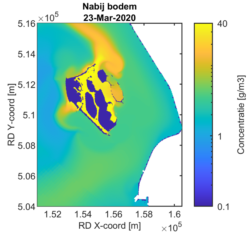
Total sediment concentration near the bed for the current lay-out of the islands
References
Deltares (n.d.). DEL169 – KIMA 2.0: Met Marker Wadden naar een robuust en klimaatadaptief Markermeer.
Retrieved from https://publicwiki.deltares.nl/spaces/TKIP/pages/260539525/DEL169+-+KIMA2.0+Met+Marker+Wadden+naar+een+robuust+en+klimaatadaptief+Markermeer
van Kessel, T., de Boer, G., Boderie, P.M.A., (2009), Calibration suspended sediment model Markermeer.
Deltares report 1200148
Genseberger, M., Borsboom, M., (2026), Exploring different domain decomposition approaches for enhanced modelling of real-life applications in lakes. Domain Decomposition Methods in Science and Engineering XXIX, Springer Nature
