
Carlijn Meijers1, Jasper Dijkstra1, Martijn klein Obbink2, Jurre de Vries2, Ellen Quataert1
1 Deltares, Netherlands; 2 Rijkswaterstaat, Netherlands
* Corresponding author: carlijn.meijers@deltares.nl
Introduction
Depth-class areas, defined as the surface area of characteristic depth classes such as channels and intertidal flats, are widely used to characterize and interpret the morphological evolution of the Wadden Sea, and are available on the ‘Digitale Systeemrapportage’ (Stolte et al., 2023). They underpin assessments of ecological habitat development (e.g. Paree et al., 2021), analyses of long‑term morphological trends and system response to sea‑level rise (e.g. Elias, 2025), and evaluations of nautical accessibility (e.g. de Wit et al., 2024). Although depth-class areas are frequently reported in studies across disciplines, their derivation is far from uniform. Differences in the spatial delineation of basins, vertical definition of depth classes and water level statistics can introduce methodological inconsistencies. These choices directly affect the magnitude and even direction of reported trends. As a result, intercomparison of studies and interpretation of long-term morphological developments is inconsistent. As the Wadden Sea faces accelerating pressures from sea‑level rise and human use, robust and comparable indicators of change are increasingly critical. This study provides a systematic evaluation of the sensitivity of area computations to commonly applied methodological choices. A uniform approach is developed that enables consistent comparison across studies, reduces methodological artefacts, and supports reliable long-term trend analysis.
Objective and Methods
The objective of this research is to quantify the sensitivity of depth‑class areas to three key methodological degrees of freedom commonly encountered in Wadden Sea studies.
(1) Horizontal basin delineation: We compared depth-class areas computed using fixed basin boundaries to variable tidal divides that migrate with morphological change (as derived in Elias, 2025). This evaluates whether changing basin geometries affect the spatial attribution of depth classes.
(2) Vertical definition of the intertidal zone: Many studies apply a uniform vertical range of −1 m to +1 m NAP as a proxy for mean low (MLW) and high water (MHW). We compared this constant range to spatially varying MLW and MHW derived from observation‑based tidal maps, acknowledging the strong west–east gradient in tidal amplitudes in the Wadden sea.
(3) Temporal variability of tidal levels: Because MLW and MHW show substantial (~10 cm) yearly fluctuations, using MLW/MHW from individual years risks conflating actual morphological change with meteorologically driven variations and the ~18.6‑year nodal cycle. We therefore tested the effect of applying yearly tidal levels versus a 19‑year running mean to isolate long-term trends in water levels such as sea level rise and tidal amplitude changes.
Results
The sensitivity analysis reveals that methodological choices can substantially influence the resulting areas and trends.
(1) Horizontal basin delineation: For most basins, differences between fixed and variable boundaries were small, indicating that migration of tidal divides does not meaningfully alter basin‑aggregated depth‑class areas.
(2) Vertical intertidal definition: Using a uniform −1 to +1 m NAP band led to systematic biases because actual MHW and MLW vary substantially across the Wadden Sea. In western basins, where the tidal range is smaller, intertidal areas were overestimated by up to 40%, while in eastern basins they were underestimated by up to 20%. Adoption of spatially varying MHW/MLW eliminates these systematic distortions.
(3) Temporal water‑level variability: Using yearly MHW/MLW values resulted in apparent intertidal area fluctuations dominated by meteorological conditions or nodal‑cycle phase, rather than genuine morphological changes. Applying a 19‑year running mean effectively filtered out non‑morphological variability and yielded more stable, interpretable long-term trends.
Understanding the morphological evolution of the Wadden Sea is vital in managing and maintaining this unique UNESCO world heritage site. Hence, a consistent and physically meaningful approach is essential to ensure inter-study comparisons reflect true morphological change rather than methodological inconsistencies.
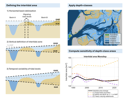
An overview of the three methodological degrees of freedom in defining the intertidal area analysed in this study, and their influence on the intertidal area of the Marsdiep (example)
References
Stolte, W., Vroom, J., Santinelli, G., Veenstra, J., van Oeveren, C., van Zelst, V., & Dijkstra, J. (2023). Digitale Systeemrapportage van de Waddenzee, versie 1.0: https://systeemrapportage.nl/wadden
Paree, E., Kers, A. S., Jentink, R., Hendriks, J.-R., & Baptist, M. J. (2021). Toelichting op de zoute ecotopenkaart Waddenzee 2017. Rijkswaterstaat.
Elias (2025), Morfologische analyse Centrale Waddenzee: een analyse van de kombergingen van het Amelander Zeegat en Friesche Zeegat. Deltares Report 11210370-003
De Wit, L., Grasmeijer, B., van Kessel, T., Dees, N. Meijers, C., & Quataert, E. (2024). Abiotische effecten baggeren en verspreiden in de Waddenzee: voorbereidende studie voor het opstellen van het tweede natura2000 beheerplan Waddenzee. Deltares report 11210370-014-ZKS-0001.
