L.M.C. Nannes1,2, W.T. Kampman2 , J.A. van Zuylen2, B.W. Borsje1, E.M. Horstman1,
1 University of Twente, the Netherlands; 2 Sweco, the Netherlands
* Corresponding author: l.m.c.nannes@student.utwente.nl
Introduction
Rapidly rising sea levels and increasing storm intensities increase the need to heighten dikes to protect coastal communities. Coastal wetlands are Nature-based Solutions that can reduce flood risk by dampening wave energy and stabilizing sediment through vegetation (Temmerman et al., 2023). This potentially reduces the need for higher dikes. However, coastal wetlands are often absent at the locations that are most vulnerable to high wave run-up (Marin-Diaz et al., 2023). Brushwood dams have shown to be effective in supporting the establishment of coastal wetlands. In contrast, the effectiveness of broad green dikes in promoting coastal wetland development remains unexplored. Therefore, a case study including broad green dikes was performed at Schiermonnikoog. The assessment of the four kilometer long Zeedijk, the Southern dike of Schiermonnikoog, showed that the dike does no longer meet the previously established flood protection standards. Consequently, dike reinforcement is necessary. Wetterskip Fryslân is exploring sustainable approaches for the reinforcement and considers to construct a broad green dike that prioritizes the natural and dynamic ecosystem of Schiermonnikoog. Therefore, the potential of salt marsh development in front of the gentle slope of a broad green dike is of high interest.
Objective and Methods
The aim of this study was “to investigate salt marsh development at the Southern coast of Schiermonnikoog and to assess the effects of a broad green dike and brushwood dams on its evolution.“ In this study we adopted a Delft3D flexible mesh model, simulating flow and sediment transport. The model is integrated with a wave module and a vegetation module, which is adopted from Willemsen et al. (2022) and Dzimballa et al. (2025), to simulate the interactions among hydrodynamics, morphodynamics, and vegetation dynamics. The validation showed that the model is considered accurate for the comparison of shoreline changes in landward or seaward direction between different scenarios, rather than for absolute interpretation of results. To assess the influence of a broad green dike on salt marsh development, a broad green dike with an outer slope of 1:10 was implemented in the input bathymetry of the model and its impact on the development of the intertidal area was compared to a normal 1:4.5 outer slope. To investigate whether brushwood dams impact salt marsh growth, they were included in the flow and wave modules of the model. Three 70 m long dams with 20 m openings, were positioned in the alongshore direction of the dike.
Results
A sensitivity analysis showed that salt marsh development is highly sensitive to changes in suspended sediment concentration and incoming wave height. A 50% decrease in suspended sediment concentration is associated with an average lateral retreat of 32.9 m of the intertidal flat over ten years. An increase of 25% in wave height corresponds to lateral retreat of 44.4 m. For comparison, the average retreat of the baseline scenario is 17.5 m.
Investigation of the influence of a broad green dike on salt marsh development revealed that the bed profiles, wave profiles remain similar to the situation with a normal, steeper dike slope. In contrast, brushwood dams reduced wave height landward of the dams. This caused reduced marsh edge erosion and accretion of the tidal flat. Lateral accretion of 26.8 m of the intertidal flat was observed compared to the normal situation without brushwood dams. The effect of brushwood dams was most pronounced for areas with high wave energy prior to installation of the dams and was systematic in the alongshore direction. The high sensitivity of salt marsh development and the lack of marsh edge accretion with brushwood dams highlight the need for sufficient suspended sediment and low wave energy.
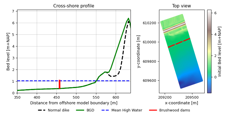
Broad green dike (BGD) and brushwood dams configuration as implemented in the model. The left subplot shows the differences between a normal dike and a BGD, and the brushwood dams with their height compared to the Mean High Water level in a cross-shore profile. The right subplot shows a top view with the locations of the brushwood dams and openings between them.
References
Dzimballa, S., Willemsen, P. W., Kitsikoudis, V., Borsje, B. W., & Augustijn, D. C. (2025). Numerical modelling of biogeomorphological processes in salt marsh development: Do short-term vegetation dynamics influence long-term development? Geomorphology, 471. https://doi.org/10.1016/j.geomorph.2024.109534
Marin-Diaz, B., van der Wal, D., Kaptein, L., Martinez-Garcia, P., Lashley, C. H., de Jong, K., Nieuwenhuis, J. W., Govers, L. L., Olff, H., & Bouma, T. J. (2023). Using salt marshes for coastal protection: Effective but hard to get where needed most. Journal of Applied Ecology, 60(7), 1286-1301. https://doi.org/10.1111/1365-2664.14413
Temmerman, S., Horstman, E., Krauss, K., Mullarney, J., Pelckmans, I., & Schoutens, K. (2023). Marshes and Mangroves as Nature-Based Coastal Storm Buffers. Annual review of marine science, 15, 95-118. https://doi.org/10.1146/annurev-marine-040422-092951
Willemsen, P. W., Smits, B. P., Borsje, B. W., Herman, P. M., Dijkstra, J. T., Bouma, T. J., & Hulscher, S. J. (2022). Modeling Decadal Salt Marsh Development: Variability of the Salt Marsh Edge Under Influence of Waves and Sediment Availability. Water Resources Research, 58. https://doi.org/10.1029/2020WR028962
