D.J. van der Hoorn1*, J.A.A. Antolínez1 , A.J.H.M. Reniers1 , P.E. Kindermann1 , K. van Asselt2 , M. van Ormondt2 , J. Groeneweg2 , V. Fernández-Quiruelas3
1 Delft University of Technology, Netherlands; 2 Deltares, Netherlands; 3 Universidad de Cantabria, Spain
* Corresponding author: danieljohan@live.fr
Introduction
The North Sea is a highly dynamic and wind-dominated basin where accurate wave modeling is essential for coastal safety, offshore operations, and long-term climate adaptation strategies. Along the Dutch coastline, flood risk is determined by compound extreme water levels, with wave-driven processes such as overtopping and dune erosion playing a crucial role. Recently, the scientific community is exploring the inclusion of long synthetic climate datasets to define hydraulic boundary conditions and estimate loads in Dutch flood safety assessments (de Valk & van den Brink, 2023; Caspers & Kindermann, 2023). Big climate data creates a growing demand for computationally efficient wave models capable of generating hundreds of multi-decadal wave hindcasts and projections while maintaining accuracy for engineering and policy applications.
HurryWave is a new third-generation spectral wave model developed by Deltares that aims to meet this demand (Van Ormondt et al., in preparation). By simplifying selected physical processes such as triad wave interactions and using an explicit numerical scheme, HurryWave achieves an order-of-magnitude reduction in computation time compared to established models such as SWAN. However, the impact of these simplifications on model accuracy in a complex basin like the North Sea has not yet been comprehensively evaluated using long observational records.
Objective and Methods
The objective of this study is to assess the performance of HurryWave in simulating wave conditions in the North Sea, with a focus on its suitability for long-term applications. In addition to analyzing three key wave parameters: significant wave height (Hm0), peak wave period (Tp), and mean wave direction (θm), special attention is given to storm events and spectral behavior, as these are critical for coastal safety assessments.
HurryWave simulations were performed for the North Sea using ERA5 wind forcing and bathymetry consistent with previous validation studies. The model was applied at multiple temporal scales, including individual years, a multi-decadal wave hindcast from 1950 to 2023, and selected extreme events such as the December 2013 “Sinterklaas storm.” Model output was evaluated against in-situ buoy observations (Digital North Sea, n.d.) and ERA5 wave data (ECMWF, n.d.). Performance was quantified using statistical metrics including root mean square error, scatter index, and bias. Furthermore, spectral output from HurryWave was compared with spectral buoy measurements to assess the model’s ability to reproduce spectral shape, energy distribution, and peak characteristics during energetic sea states.
Results
Results show that HurryWave reproduces significant wave height with skill comparable to ERA5 at many shallow-water and nearshore stations in the southern North Sea, with typical RMSE values between 0.35 and 0.55 m and scatter indices of 0.12–0.20. Sensitivity experiments indicate that extending the model domain westward to 25°W and northward to 80°N, rather than limiting it to 12°W and 65°N as in the standard North Sea configuration, substantially reduces boundary effects when offshore forcing is omitted. When the domain is restricted to the southern North Sea without offshore boundary forcing, wave heights at deeper offshore stations are strongly underestimated. Across the domain, extreme wave heights remain underestimated, partly due to underestimation of high wind speeds in the ERA5 forcing.
Peak wave period is generally underestimated (RMSE 1.5–2.5 s and bias up to −1.5 s), while mean wave direction shows the weakest performance, particularly during storms. Spectral analysis indicates that HurryWave captures overall storm evolution but produces narrower spectra than observed, attributable to simplified nonlinear interactions. Overall, HurryWave is well suited for efficient long-term wave climatology generation, particularly for significant wave height, but remains less suitable for applications requiring detailed accuracy.
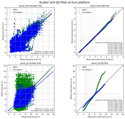
Comparison of HurryWave and ERA5 results against buoy observations at Euro Platform for the period 1950–2023. The left panel shows scatter plots of modelled versus observed 𝐻𝑚0 and 𝑇𝑝 , while the right panel presents sorted quantile plots. The results reveal that significant wave height is well captured, whereas peak period is systematically underestimated at higher quantiles. ERA5 underestimates low quantiles and overestimates high ones, indicating greater variability but reduced central accuracy compared to HurryWave
References
Caspers, J. J., & Kindermann, P. E. (2023). Hydraulic load model for the Dutch shore (PR4529.20). HKV lijn in water. https://open.rijkswaterstaat.nl/zoeken/@268755/hydraulic-load-model-for-the-dutch-shore/
de Valk, C. F., & van den Brink, H. W. (2023). Update van de statistiek van extreme zeewaterstand en wind op basis van meetgegevens en modelsimulaties (Technical Report TR-406; p. 89). KNMI. https://www.knmi.nl/research/publications/update-van-de-statistiek-van-extreme-zeewaterstand-en-wind-op-basis-van-meetgegevens-en-modelsimulaties
ECMWF. (n.d.). The family of ERA5 datasets—Copernicus Knowledge Base—ECMWF Confluence Wiki. Retrieved March 16, 2025, from https://confluence.ecmwf.int/display/CKB/The+family+of+ERA5+datasets
van Ormondt, M., van Asselt, K., van Dongeren, A. R., & van der Lugt, M. (in preparation). HurryWave: A Fast and Efficient Third-Generation Spectral Wave Model [Unpublished manuscript].
Wave measuring buoy | Digital North Sea. (n.d.). Retrieved March 16, 2025, from https://www.digitalnorthsea.nl/data/hydrological-data/wave-measuring-buoy
