S. Dzimballa1*, V. Kitsikoudis1, E.O. Folmer2, P.W.J.M. Willemsen3,4, B.W. Borsje1, D.C.M. Augustijn1
1 Water Engineering and Management, University of Twente, The Netherlands; 2 Lumax Ecological Analytics, Lemmer, The Netherlands; 3 Hydrology and Environmental Hydraulics Group, Department of Environmental Sciences, Wageningen University & Research, The Netherlands; 4 Department of Ecosystems and Sediment Dynamics, Deltares, The Netherlands.
* Corresponding author: s.dzimballa@utwente.nl
Introduction
Salt marshes are increasingly recognized as nature-based solutions for coastal protection. Their capacity to attenuate waves and reduce erosion depends on marsh width, which is strongly shaped by environmental limits governing establishment and persistence at the dynamic seaward edge. Vegetation establishment at the marsh edge is governed by interacting hydrodynamic, geomorphological, and biological processes operating across multiple spatial and temporal scales. Key drivers include tidal inundation regimes, wave and current stress, sediment availability and stability, elevation within the tidal frame, and fine-scale features such as microtopography and drainage. These factors determine seedling survival, biomass production, erosion risk, and the balance between marsh expansion and retreat.
Along the mainland coast of the Dutch Wadden Sea, marsh development has been influenced by decades of management interventions. Sedimentation fields and brushwood dams attenuate wave energy and promote sediment accretion, thereby modifying hydrodynamic and morphodynamic conditions at the marsh edge. How these modified local conditions affect seaward-edge dynamics and the elevation thresholds for vegetation establishment remains insufficiently understood. This study quantifies how local hydrodynamic and geomorphological conditions control vegetation establishment thresholds, using high-resolution UAV-derived data across multiple sites. The resulting insights support site-specific management strategies to strengthen long-term marsh resilience under accelerating sea-level rise.
Objective and Methods
High-resolution UAV (Unmanned Aerial Vehicles) surveys were conducted at five mainland salt marshes in the Dutch Wadden Sea (Holwerd East, Holwerd West, Wierum, Paesens, and Deikum) between 2023 and 2025, with campaigns in winter/spring (Dec–Mar) and summer/autumn (Aug–Sept). Photogrammetrically derived digital elevation models (DEMs) and orthomosaics serve as the primary dataset from which a terrain ruggedness index was calculated. The DEMs are validated using Ground Check Points with a vertical accuracy of 1-5cm.
These datasets were used to train a random forest classifier to distinguish vegetated from unvegetated surfaces, with additional capability to differentiate annual (Salicornia) from perennial (low, mid, and high) salt-marsh species. To assess the classifier's universality, models trained on one marsh and season were tested on other marshes and seasons. Detailed vegetation density maps were then used to extract the marsh edge based on a 5% vegetation cover threshold. Corresponding edge elevations were obtained from the DEMs on the unvegetated mudflat, enabling comparisons of elevation thresholds across space and time and between the different marshes. The determined edge elevations were subsequently related to local hydrodynamic conditions (mean high water levels (MHW) and cumulative wave energy), morphodynamic conditions (local elevation change), and sheltering by brushwood dams.
Results
The random forest classifier successfully distinguished vegetated from unvegetated areas, achieving up to 98% accuracy in the test set, and reliably separated annual from perennial salt-marsh species. Feature importance analysis showed a high importance of the DEM (>60%) and the ruggedness index (around 10%). Each RGB spectral band has a feature importance ranging from 5% to 9%. This shows that, in the absence of the infrared band, commonly used for vegetation classification, the DEM and ruggedness index can provide important information for marsh classification.
The analysis of spatial variability in marsh-edge elevation has revealed differences that cannot be explained solely by differences in MHW levels. Additional analyses revealed that local hydrodynamic forces, particularly wave exposure derived from the SWAN Kuststrook model in front of each location, influence the minimum elevation at which vegetation can establish (e.g., at Paesens). Sheltering effects from brushwood dams further modify local thresholds, enabling establishment at lower relative elevations. Furthermore, local morphological features, such as the salt marsh cliff at the Wierum marsh, can lead to higher edge elevations.
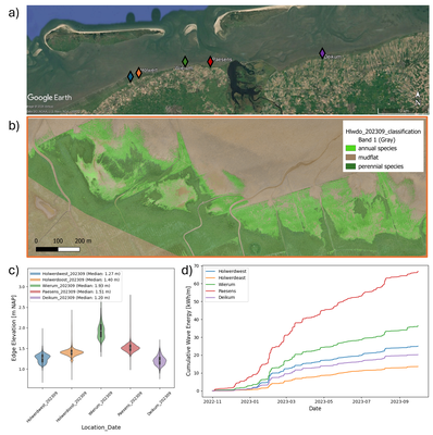
(a) An overview of the study sites along the Dutch Wadden Sea, created using Google Earth imagery. (b) A UAV-derived orthomosaic, taken in September 2023, overlaid with the classified salt marsh at Holwerd East, showing annual species in light green and perennial species in dark green. (c) Salt marsh edge elevations at different sites in the Dutch Wadden Sea, taken in September 2023. (d) Cumulative wave energy reaching the different sites between November 2022 and October 2023.
