B.P. Smits1*, F. Brils2 , R.J.A. Van Weerdenburg1,3
1 Deltares, The Netherlands; 2 Rijkswaterstaat WVL, The Netherlands; 3 TU Delft, The Netherlands
* Corresponding author: Bob.Smits@deltares.nl
Introduction
The tidal channel Boontjes in the Dutch Wadden Sea is an important connection for navigation between the Afsluitdijk locks at Kornwerderzand and Harlingen. The dimensions of the channel have been maintained over the past years by extensive dredging, up to a yearly dredging volume of 360,000 m3 in 2019. Based on previous Deltares analyses (Colina Alonso et al., 2021; Smits et al., 2022) a pilot is started in 2025 to reduce the amount of maintenance dredging and its impact on the Wadden Sea. During the pilot, the maintenance depth of the channel is reduced from -3.80 m NAP to -3.30 m NAP. The effects of the pilot are being monitored by several monitoring campaigns, focusing on hydrodynamics, morphology, and benthic communities.
Objective and Methods
The monitoring program is designed to quantify whether the reduction in maintenance depth is an effective measure to reduce dredging impact. Prior to the start of the pilot, a (T0-)measurement campaign was carried out to assess baseline conditions. A measurement campaign was carried out by Rijkswaterstaat, by deployment of four measurement frames placed in the study area between 8 October 2024 and 16 December 2024. These frames were equipped with ADCP, ADV, OBS and CTD instruments. Additionally, ship-based measurements are performed along four cross-sections, also using ADCP, OBS, and CTD. These ship-based measurements are performed during 13-hour spring and neap tide periods in October.
This study contains the data analysis of the monitoring data of the first (T0) measurement campaign, to obtain more insight into system dynamics, including sediment transport, wind effects and freshwater dynamics (testing a hypothesis by Schulz & Gerkema, 2018). These insights support evaluation of the pilot in subsequent years. Additional measurement campaigns are and will be performed in 2025 and 2026, as presented to the NCK community in another (poster) contribution.
Results
The analysis of the monitoring data reveals that the tidal divide of the Marsdiep and Vlie basins is not located in the Boontjes, as ebb- and flood currents are in the same direction over the entire channel (ebb to the north, and flood to the south). Suspended sediment concentrations are significantly larger during flood, causing a residual transport towards the north. Suspended sediment concentrations and transport rates increase during windy periods (corresponding with findings by Colosimo et al., 2020), for which we are to find out whether this is caused by local resuspension or increased sediment supply from other areas.
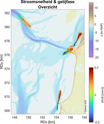
Grootte en richting van de gemeten snelheidsvectoren op de vier meetlocaties tijdens de gehele meetperiode. De meetlocaties zijn weergeven met een +. Schaal stroomsnelheden: 1 m/s : 1 km op de achtergrondkaart. De kleur toont de verandering van de waterstand en daarmee een indicatie van de fase in het getij.
References
Colina Alonso, A., Smits, B.P., Vroom, J.A. (2021). Stijging Baggerhoeveelheden Vaargeul Boontjes. Deltares rapport 11206799-007-ZKS-0001. Deltares, Delft. 93 pp.
Colosimo, I., de Vet, P. L., van Maren, D. S., Reniers, A. J., Winterwerp, J. C., & van Prooijen, B. C. (2020). The impact of wind on flow and sediment transport over intertidal flats. Journal of Marine Science and Engineering, 8(11), 910.
Schulz, K.& Gerkema, T. (2018). An inversion of the estuarine circulation by sluice water discharge and its impact on suspended sediment transport. Estuarine, Coastal and Shelf Science, 200, 31-40
Smits, B.P., Vroom J.A., Van Weerdenburg, R., Colina Alonso, A. (2022). Morfologie en Onderhoud Vaargeul Boontjes: Systeembegrip en Scenario’s. Deltares rapport 11208040-004-ZKS-0004. Deltares, Delft. 66 pp.
