M.E. Broenink1,2, E.M. Horstman1, R. Gijsman3, S. Engel4, K.M. Wijnberg1, M. van der Geest2
1 Coastal Systems and Nature-based Engineering, Faculty of Engineering Technology, University of Twente, Enschede, Netherlands, 2 Wageningen Marine Research, Wageningen University & Research, PO Box 57, 1780 AB Den Helder, the Netherlands, 3 Coastal and Urban Risk and Resilience, IHE Delft Institute for Water Education, Delft, Netherlands, 4 Mangrove Maniacs, Kralendijk, Bonaire, Caribbean Netherlands
* Corresponding author: m.e.broenink@student.utwente.nl
Introduction
Lac Bay in Bonaire (Caribbean Netherlands) hosts an atypical mangrove ecosystem without riverine input, making it particularly sensitive to evaporation-driven hypersalinity. The system consists of a fringing reef, a bay, and a mangrove forest, and is part of the Bonaire National Marine Park. The region is characterised by a semi-arid tropical climate with persistent easterly trade winds and limited freshwater availability, resulting in a strongly evaporation-dominated water balance. The mean tidal range at the seaside of the mangrove system is approximately 0.28 m, but attenuates to less than 0.04 m in the landward basin (Awa di Lodo). This microtidal setting creates strong spatial gradients in inundation frequency, as well as temporal variability in tidal exchange between the bay and Awa di Lodo. Progressive sedimentation within the tidal creeks in the mangroves further reduces hydraulic connectivity, increasing the system’s sensitivity to hypersaline conditions. The landward basin is nowadays characterised by shallow, hypersaline waters and widespread mangrove die-off, indicating a structural loss of hydraulic connectivity with the bay. Despite recognition that tidal exchange is fundamental for mangrove functioning, the quantitative relationship between hydrodynamic exchange and salinity dynamics remains insufficiently understood.
Objective and Methods
The study aims to quantify how reduced tidal connectivity controls salinity dynamics in a microtidal mangrove system, and to identify hydrodynamic thresholds required to sustain sufficient tidal exchange. This understanding is subsequently used to assess the vulnerability of the mangrove system to reduced tidal flushing and to evaluate the effectiveness of restoration strategies through hydrodynamic modelling. To quantify the hydrodynamic processes, a field campaign was conducted between May and November 2025, during which water levels, flow velocities, and salinity were measured across Lac Bay, the tidal creeks, the forest platform, and Awa di Lodo. Water level observations were used to characterise tidal forcing in the bay and the attenuated hydrodynamic response across the mangrove ecosystem. Flow measurements in the creeks were used to assess the dominant flow directions and relative discharge capacities, while salinity measurements were used to assess how variations in tidal connectivity through the creeks influence salt accumulation and flushing in Awa di Lodo. The observational analysis was integrated with a 2D hydrodynamic model (3Di) to explore the system’s resilience under different restoration strategies, informing adaptive management of Caribbean mangrove ecosystems.
Results
Preliminary results reveal pronounced tidal attenuation and clear threshold behaviour in the exchange between Lac Bay and Awa di Lodo. For peak water levels below approximately 0.19–0.25 m above mean sea level, the tidal response in Awa di Lodo remains limited to only a few centimetres. Once this threshold is exceeded, the tidal range in Awa di Lodo increases rapidly and non-linearly, indicating activation of hydraulic connectivity via the creeks. Although complete isolation of Awa di Lodo was not observed, periods of low tidal exchange coincided with rapid salinity increase, whereas stronger tidal forcing corresponded to salinity decline. This transition occurred near the identified hydrodynamic threshold, suggesting that tides below a specific peak water level in the bay lead to reduced flushing and increased salinity. Model simulations confirmed that increasing channel capacity enhanced flushing of Awa di Lodo. Ongoing scenario analysis, including the addition of an extra tidal creek and deepening of Awa di Lodo, will indicate how such interventions may shift the system toward a more connected regime. These simulations will provide quantitative insights that can inform restoration measures to reduce vulnerability of microtidal mangroves to hypersaline conditions.
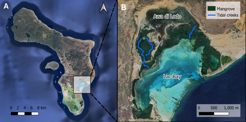
(A) Map of Bonaire with the study area located within the square. (B) Close-up of the study area showing Lac Bay, the mangrove forest, the primary tidal creeks, and the backwaters of Awa di Lodo.
