
G. Donchyts 1*, G. Santinelli1, A. P. Luijendijk1,2, F. Baart1, M. Verlaan1,2
1 Deltares, This email address is being protected from spambots. You need JavaScript enabled to view it., This email address is being protected from spambots. You need JavaScript enabled to view it., This email address is being protected from spambots. You need JavaScript enabled to view it.,
2 Delft University of Technology, This email address is being protected from spambots. You need JavaScript enabled to view it., This email address is being protected from spambots. You need JavaScript enabled to view it.
Monitoring of the intertidal and subtidal bathymetry at large spatiotemporal scales using traditional surveying methods is a challenging and costly task. Well established methods of remote sensing and increasing frequency of freely available satellite data enable automated monitoring of intertidal and subtidal bathymetry. A number of methods exist to extract intertidal bathymetry by combining the observed water masks with the water level data simulated by intertidal numerical models and local water level measurements. At the same time, the light attenuation in a water column, observed by optical satellite sensors, can be used to estimate water depth, providing a way to estimate subtidal bathymetry. In this research, we will discuss how both these methods can be combined to generate a consistent intertidal and subtidal bathymetry data.
The algorithm based on water occurrence for intertidal waters and optical reflectance for the subtidal region has been applied in Dutch open waters, providing promising insights. The use of tidal variability and empirical optical characteristics enabled to characterise depth in the intertidal and some of the subtidal areas. Furthermore, the method makes use of variability in bottom reflectance detected by the satellite as that is covered by different water columns. A great advantage in the estimation of satellite-derived bathymetries is the high temporal frequency of sampling provided by the satellite sensors, addressing the need for data on short-duration morphological changes.
The results of this research were used to improve the European Marine Observation and Data Network (EMODnet) bathymetry. The research was supported by the European Commission and the Dutch Ministry of Infrastructure and Water Management.
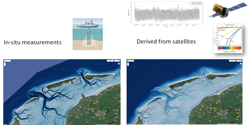
Figure 1 Vaklodingen Bathymetry (de facto in-situ data source for Dutch waters) on the left and Satellite-Derived Bathymetry on the right. Source: https://earthengine.google.com.