
S. Eslami Arab1, M. van der Vegt1*, N. Nguyen Trung2, H. Kernkamp3, A. Van Dam3, P. Hoekstra1,
1 Utrecht University, This email address is being protected from spambots. You need JavaScript enabled to view it.,
2 Southern Institute for Water Resources Research, This email address is being protected from spambots. You need JavaScript enabled to view it.
3 Deltares, This email address is being protected from spambots. You need JavaScript enabled to view it.
3 Deltares, This email address is being protected from spambots. You need JavaScript enabled to view it.
1 Utrecht University, This email address is being protected from spambots. You need JavaScript enabled to view it.,
Introduction
The low-lying and rapidly urbanizing Mekong Delta is experiencing land subsidence rates in the order of 1-4cm/yr, in response to excessive ground water extraction, that are exceeding sea level rise. Furthermore, sand mining is changing channel geometries; hence, tidal propagation is changing in the estuarine channel system. By accelerated dam construction further upstream in upper and lower Mekong basins, sediment supply has declined, resulting in coastal, channel and bank erosion. All above mechanisms contribute to increased salt intrusion, which is portrayed in the land-use change (e.g. agriculture to aquaculture) and record numbers of salt intrusion events.
Methods
we analyse a noble dataset of 20-year record of water level (e.g. see Figure ), discharge and stationary salinity measurements and extract trends of tidal deformation and saline water intrusion. Furthermore, by application of an extensively calibrated 1D-2D coupled Mekong-wide barotropic model (in D-Flow Flexible Mesh), we explain the observed trends and link those trends to shifts in the upstream regime. The observed salinity trends could be physically explained and related to water level and discharge observations, by application of commonly-used salinity models.
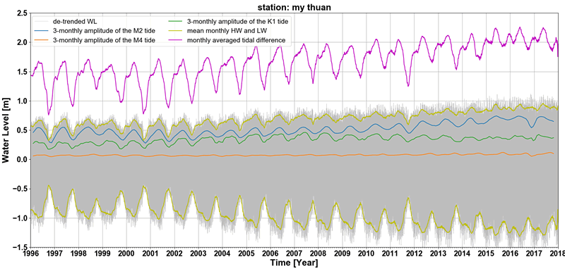
Figure 1. The observed historical variation of de-trended, tidal water level, M2, M4 & K1 variations, and tidal difference at a measurement station in the Mekong Delta
Results
Our analysis shows an increase in salt intrusion and tidal amplitudes along several branches. The in-depth analysis of the model results and studying the short-term processes revealed a crucial role for subtidal water level in temporal variation of freshwater in the multi-channel estuarine system. In studying the long-term processes, the model was used to provide additional argumentation that the changes in tidal characteristics are related to morphological changes in response to anthropogenic processes. The observed trends and the modelled physical reveal that anthropogenic activities out-pace global climate change effects on the region. The fate of this mega delta solely depends on bold, integrated, inter-disciplinary and trans-boundary governance and management measures that require immediate actions.