
Qing He1, Weiming Xie1, Xianye Wang1
1 State Key Lab of Estuarine and Coastal Research, ECNU, This email address is being protected from spambots. You need JavaScript enabled to view it., This email address is being protected from spambots. You need JavaScript enabled to view it., This email address is being protected from spambots. You need JavaScript enabled to view it.
Intertidal environments, including bare mudflats, tidal creeks, and vegetated salt marshes, are of significant physical and ecological importance in estuaries. Understanding water motion and sediment transport in mudflats and tidal creeks is fundamental to understand intertidal morphodynamics in intertidal environments. To explore dynamic interactions between tidal creeks and mudflats, we conducted field campaigns monitoring water depths, tidal currents, waves, suspended sediments, and bed-level changes at sites in both mudflats and tidal creeks in the Yangtze Delta for a full spring-neap tidal cycle. We saw that under fair weather conditions, the bed-level changes of the tidal creek site displayed a contrary trend compared with those of the mudflat site, indicating the source-sink relationship between tidal creek and mudflat. During over-marsh tides, the tidal creek site with relatively high bed shear stresses was eroded by 35mm whereas the mudflat site was accreted by 29mm under low bed shear stresses. To the contrast, during creek restricted tides, deposition occurred in the tidal creek site by 20mm under low bed shear stresses whereas erosion occurred in the mudflat site by 25mm under relatively high bed shear stresses. Over a spring-neap tidal cycle, the net bed level changes were -15mm (erosion) and 4mm (deposition) in tidal creeks and mudflats, respectively. These results suggested that there were alternated erosion-deposition patterns in spring and neap tides, and a sediment source and sink shift between mudflats and creeks. We found that the eroded sediments in mudflats were transported landward into tidal creeks and deposited therein in neap tides, and these newly deposited sediments would be resuspended and transported to surrounding marshes (over-marsh deposition) at spring tides. The coherent sediment transport and associated erosion-deposition pattern within the mudflat-creek system at spring-neap tidal time scales thus played a fundamental role in intertidal morphodynamic development. These findings suggest that management and restoration of intertidal ecosystem need to take the entire mudflat-creek-marsh system as a unit into consideration rather than focusing on single elements.
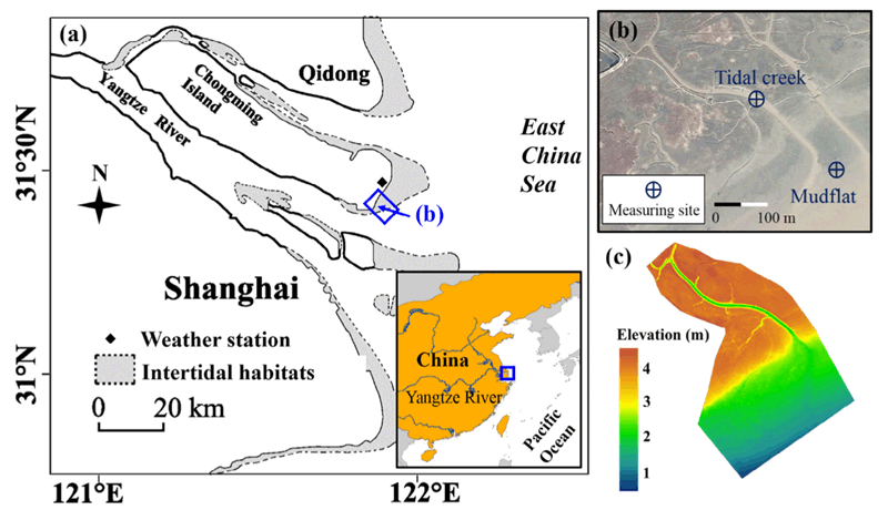
Fig. 1. Map of the Yangtze Estuary, location of Eastern Chongming weather station (a) and a view of the study site and locations of the two measuring sites (b), and Digital elevation model of the study area derived from Terrestrial Laser Scanning data collected in August 2016 (c).