S.M. Beselly1,2,5*, M. van der Wegen1,3, D. Roelvink1,2,3, U. Grueters4, J. Reyns1,3,J. Dijkstra3,.
1 IHE Delft Institute for Water Education, 2Delft University of Technology, 3 Deltares, 4Institute of Plant Ecology, Justus-Liebig-University of Giessen, Germany, 5Water Resources Engineering Department, Universitas Brawijaya, Indonesia.
Introduction
The LUSI [acronym of LUmpur (mud) and SIdoarjo (the regency name)] mudflow is reported to be the "largest mud eruption in the world". On 29 May 2006, the boiling mud erupted at a peak flow rate of up to 180,000m3/day. Sixty thousand people were forced to evacuate, and 7km2 of residential area was submerged with mud. LUSI is still actively erupting mud material, gas, water, clasts and oil albeit at a reduced rate. Indonesian government built 10m tall embankments to hold the continuous mudflow and regulate the diversion to the Porong River. These mudflow diversion operations profoundly influenced the estuarine morphology. The delta is rapidly prograding along with the development of mangrove belts. With no end of the mudflow in sight, its influence to delta formation and mangrove ecosystem dynamics urges research on the expected delta progradation and mangrove belt expansion.
Methods
Datasets are required to validate a coupled mangrove dynamics (mesoFON) and Delft3D-FM model. A field campaign in November 2019 is combined with 12 years of observations in Porong Delta, Indonesia. During the field campaign, a bathymetry survey, sediment and water quality samples were analysed. Six sediment traps were also installed perpendicular and parallel to the channel to observe the sedimentation rate on the edge of mangrove forests. One of the key processes of our numerical model is the inclusion of mangrove dynamics. However, the vegetation dynamic model requires mangrove biophysical properties, which mostly relied on traditional forest inventory observation methods. In this research, we used structure-from-motion (SfM) photogrammetry to generate a high-resolution spatial canopy height model (CHM) for the mangroves. This approach is used to determine the structural characteristics of mangrove stands and is validated with ground-truthing. Based on the resulted CHM, the structural information of mangroves (e.g. height and above ground biomass) can be retrieved by using the rLIDAR package in R.
Results
We observed that, in over 12 years, the LUSI-based sediments generated a new delta with a total area of approximately 1.75 km2 compared to 0.05 km2 before the eruption. Sediment trap dry volume measurement shows an average increase rate sedimentation of 17cm3/day. The regional climate conditions and added nutrient flux to the new delta have likely provided a suitable environment to promote the development of mangrove species, such as Avicennia spp., Rhizophora spp., and Sonneratia spp. Analysis of photogrammetry data shows that drone-based observations of the mangrove canopy height are a useful tool to provide data of mangroves characteristics as input to and validation of vegetation dynamics. We used consumer drone DJI Mavic Pro with 75% front overlap, 70% side overlap and 60m flight altitude. The achieved DEM resolution is 5.2cm/pixel.
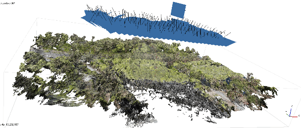
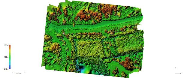
Figure 1 Example of drone imageries processed with SfM photogrammetry. Top: Mangroves dense point cloud. Bottom: SfM photogrammetry DEM.
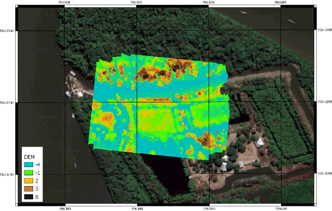
Figure 2 Example of georeferenced DEM overlay to satellite image.
I. Surname1*, F.N. Another-Surname2 , Y. Next-Surname2
1 University Name, Country; 2 Organization Name, Country
* Corresponding author: mail.name@organization.org
