J.J. Oude Vrielink1,2*, M.A. Eleveld2, B. van der Valk2, B. van Westen2, G. Hendriksen2, S. IJff2, F. van der Meulen3, R.C. de Zeeuw4, M.R. van Eerden5, K. Borst5, F. Galiforni-Silva1, K.M. Wijnberg1
1 University of Twente, 2 Deltares, 3 Van de Meulen Consultancy, 4 Shore Monitoring & Research, 5 Rijkswaterstaat
Corresponding author:
Introduction
In 2009 a new dune area called Spanjaards Duin was constructed in front of the Delfland Coast. Spanjaards Duin was created as a compensation measure for the expected increase in nitrogen deposition from the expansion of the Rotterdam harbour (Maasvlakte 2). The predefined compensation goal is to reach 6 ha of moist dune slack vegetation and 10 ha of dry grey dune in 2033. This is pursued by creating favourable abiotic conditions for natural vegetation establishment (van der Meulen et al., 2014). Sediment fluxes affect establishment and growth of vegetation and shape the dune landscape. Therefore, there is need to know how sediment fluxes behave in Spanjaards Duin.
Methodology
Over the past decade, the morphological development has been monitored with LiDAR sensors (on UAV and airplane). Timeseries of elevation profiles were extracted to study cross-dune morphological development with and without beach houses, and also effects of the planting of marram grass on the foredune. The impact of marram grass on sediment fluxes across the foredune is currently modelled using a numerical aeolian sediment transport model, AeoLiS (Hoonhout & de Vries, 2016). Sediment fluxes within the dune valley were studied by analysing sediment accretion rates in a series of artificial reed bundle fields. Finally, erosion of artificial blowouts was studied by creating a conceptual model focusing on wind steering by morphology.
Results
The presence of beach houses reduced deposition rates on the stoss side of the foredune, most likely due to sediment transport blocking by the houses, whereas morphological impact on the valley located directly behind the foredune seems minor (fig 1). The planting of vegetation resulted in pronounced development of the foredune in terms of height. In the dune valley sediment was deposited within the reed bundle fields, with highest accumulation rates in the field that is most exposed to wind blowing through the valley. Preliminary results show that erosion patterns within blowouts can be predicted from the wind climate.
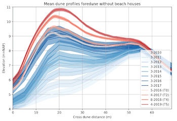
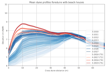
Figure 1 Mean dune profile development for (left) a foredune area without and (right) a foredune with beach houses in front on the beach. North Sea on the left side of the figures.
References
- Hoonhout, B. M. & de Vries, S. (2016). A process-based model for aeolian sediment transport and spatiotemporal varying sediment availability. J. Geophys. Res.: Earth Surface, 121 (8), 1555-1575.
- van der Meulen, F., van der Valk, B., Baars, L., Schoor, E. & van Woerden, H. (2014). Development of new dunes in the Dutch Delta: nature compensation and 'building with nature'. J. Coast. Cons., 18 (5), 505-513.
I. Surname1*, F.N. Another-Surname2 , Y. Next-Surname2
1 University Name, Country; 2 Organization Name, Country
* Corresponding author: mail.name@organization.org
