
S.A.H. Weisscher1*, M.G. Kleinhans1
1 Utrecht University,
Introduction
Stratigraphic records show that many Holocene estuaries were infilled and closed off from the sea, but how is unclear. Yet, understanding how to build and raise land to keep up with future sea level rise is urgently needed. We think that mud and vegetation play a crucial part in this process by elevating bars and confining flow and aim to unravel experimentally how these factors affect the filling of estuaries.
Methods
Experiments were conducted in the 20x3m tilting flume the Metronome that simulated net infilling estuaries from an initially long rectangular basin with barrier islands (Fig. 1). Tidal flow was driven by periodical tilting of the flume, which favoured ample and realistic sediment transport in both the flood and ebb direction. Tilting was done asymmetrically (flood asymmetry; M2+M4) such that sediment was net imported. We ran three experiments: one control with sand, a second with sand and mud and a third with sand, mud and vegetation. Mud was simulated as crushed walnut shell, and sprouts of three vegetation species with different colonising strategies simulated natural vegetation.
We modelled shallow flow in the experiments using the numerical model Nays2D. This modelling approach was validated for scaled river and estuary experiments (Weisscher et al., in prep.) and produces spatiotemporally continuous data of better overall quality than in-situ measurements. Nays2D takes as input a DEM and the corresponding boundary conditions (i.e., tilting parameters, hydraulic roughness, river discharge, grain size) and produces maps of water depth, flow velocity, residual flow and sediment mobility on the resolution of the DEM.
Results
Mud and vegetation mainly settled on intertidal flats and the fluvial bayhead delta. Consequently, bar mobility was strongly reduced, and preservation potential increased in the landward direction. The estuary was narrowed by vegetation colonisation and land formation on large side and mid-channel bars (right column in Fig. 1), which contributed to stronger flood flows that transported sediment further into the basin. The net filling from the landward side caused the tidal prism to drop over the course of the experiments, especially when mud and vegetation were included.
References
Weisscher, S.A.H., Boechat-Albernaz, M., Leuven, J.R.F.W., Van Dijk, W.M., Shimizu, Y. and Kleinhans, M.G. (in prep). Implementing a hydrodynamic model to complement water depth and flow velocity data for physical scale experiments of rivers and estuaries.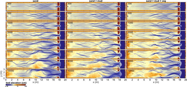
Figure 1 Morphological development of three net infilling estuaries with the number of tidal cycles in the upper left corner for each DEM.
I. Surname1*, F.N. Another-Surname2 , Y. Next-Surname2
1 University Name, Country; 2 Organization Name, Country
* Corresponding author: mail.name@organization.org
