Nadia Bloemendaal1, Ivan D. Haigh2, Hans de Moel1, Sanne Muis1,3, and Jeroen C.J.H. Aerts1
1. Institute for Environmental Studies (IVM), Vrije Universiteit Amsterdam,
2. School of Ocean and Earth Science, National Oceanography Centre, University of Southampton,
3. Deltares,
Introduction
Tropical cyclones (TCs), also referred to as hurricanes or typhoons, are amongst the deadliest and costliest natural disasters, affecting people, economies and the environment in coastal areas around the globe when they make landfall. In 2017, Hurricanes Harvey, Irma and Maria entered the top-5 costliest Atlantic hurricanes ever recorded, with combined losses estimated at $220 billion. Therefore, to minimize future loss of life and property and to aid risk mitigation efforts, it is crucial to perform accurate TC risk assessments in low-lying coastal regions. Calculating TC risk at a global scale, however, has proven to be difficult, given the limited temporal and spatial information on landfalling TCs around much of the global coastline.
Methods
In this research, we present a novel approach to calculate TC risk under present and future climate conditions on a global scale, using the newly developed Synthetic Tropical cyclOne geneRation Model (STORM). For this, we extract 38 years of historical data from the International Best-Track Archive for Climate Stewardship (IBTrACS). This dataset is used as input for the STORM algorithm to statistically extend this dataset from 38 years to 10,000 years of TC activity. The resulting STORM dataset is then used to estimate global-scale wind speeds at various return periods, at 10 km resolution.
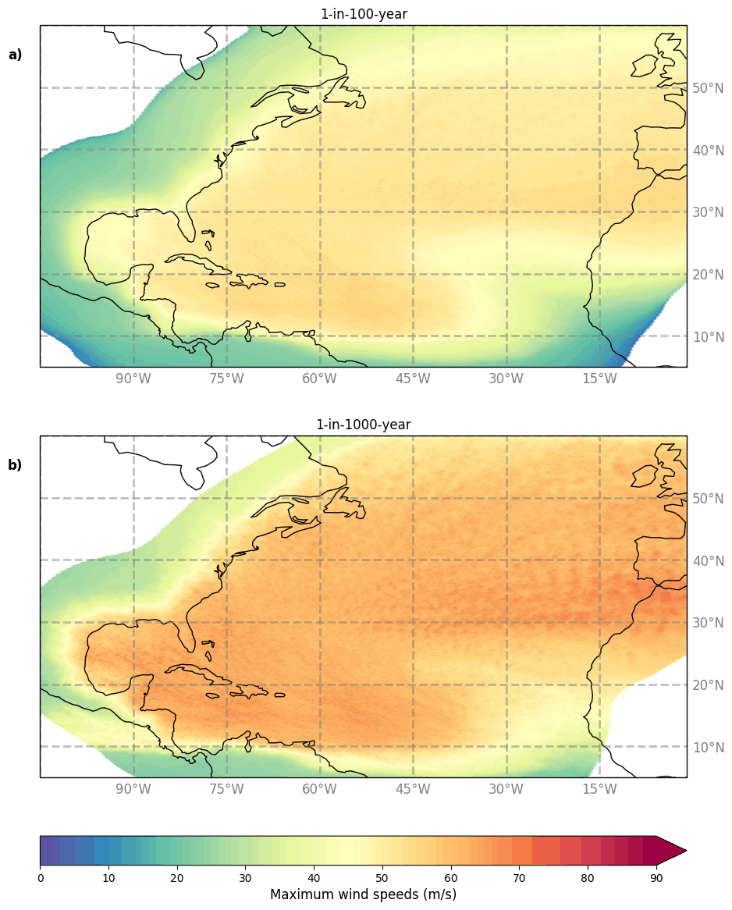
Figure 1 Wind speed return periods in the North Atlantic basin. Here shown are the 1-in-100 year (a) and the 1-in-1000 year maximum wind speeds.
Results
Validation shows that the STORM dataset preserves the TC statistics as found on the original IBTrACS dataset. The return period dataset can then be used to assess the low probabilities of extreme events all around the globe. Moreover, we demonstrate the application of this dataset for TC risk modeling on small islands in e.g. the Caribbean or in the South Pacific Ocean.
I. Surname1*, F.N. Another-Surname2 , Y. Next-Surname2
1 University Name, Country; 2 Organization Name, Country
* Corresponding author: mail.name@organization.org
