J.L.J. Hanssen1,2*, P.M.J. Herman1,2, B.C. van Prooijen1,2
1 Delft University of Technology, Delft, The Netherlands
2 Deltares, Delft, The Netherlands
*corresponding author:
Introduction
The natural evolution of tidal flats is affected by human interference worldwide, (e.g., coastal squeeze, dredging and disposal (van Dijk et al., 2019)). Managing these tidal flats requires understanding how the morphology of tidal flats responds to human interference. Current research often describes the flat shape qualitatively as convex-up and concave-up for accreting and eroding flats, respectively. However, several processes have been identified to affect the shape of different parts of a tidal flat (Maan et al., 2018). A tool that describes the cross-shore tidal flat shape quantitatively does not exist yet. In this research, we develop a model to predict the cross-shore flat shape while taking into account the effects of the accommodation space (area between dike and tidal channel), as well as the hydrodynamic and sediment characteristics.
Methods
A tool is developed to systematically analyse the cross-shore shape of tidal flats in the Western Scheldt. The cross-shore profiles are deduced from bathymetry data of the intertidal and subtidal area for the past two decades. Then, three zones are defined for each cross-shore profile: the lower flat, upper flat, and the transition zone of the tidal flat in between. Based on a shape function for the bed level, we quantify the flat shape parameters of each element: the length, elevation and the slope of the lower and upper flat.
Results
Our tool automatically extracts numerous cross-shore profiles along the entire estuary for multiple years (Figure 1). Figure 1B shows the evolution of one transect over time. The results show that parts of a tidal flat erode or accrete independent from each other. Also, not every tidal flat fits into the category of convex-up or concave-up. This highlights the importance of evaluating different parts of the cross-shore tidal flat profile separately. We are able to fit the mathematical expression to the cross-sections and obtain the flat shape parameters. Next, we combine this spatial and temporal datasets with hydrodynamic and sediment data to evaluate relations between physical forcing mechanisms and changes in the shape parameters. This tool to assess tidal flat shape changes contributes to a better understanding of the tidal flat evolution.
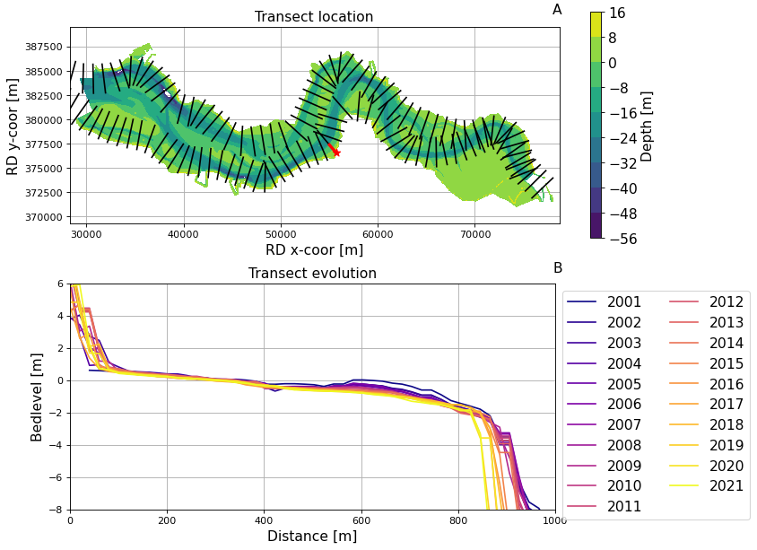
Figure 1: A) overview of the intertidal and subtidal area in the Western Scheldt and derived cross-section (red). B) Evolution of a cross-section in the past decades
Maan, D. C., van Prooijen, B. C., Zhu, Q., & Wang, Z. B. (2018). Morphodynamic Feedback Loops Control Stable Fringing Flats. Journal of Geophysical Research: Earth Surface, 123(11), 2993–3012. https://doi.org/10.1029/2018JF004659
van Dijk, W. M., Cox, J., Leuven, J., Cleveringa, J., Taal, M., Hiatt, M., Sonke, W., Verbeek, K., Speckmann, B., & Kleinhans, M. (2019). The vulnerability of tidal flats and multi-channel estuaries to dredging and disposal. https://doi.org/10.31223/OSF.IO/67WXG
I. Surname1*, F.N. Another-Surname2 , Y. Next-Surname2
1 University Name, Country; 2 Organization Name, Country
* Corresponding author: mail.name@organization.org
