J.B. Woerdman1*, M.A. van der Lugt2, M. klein Obbink1, B.G. Ruessink1, M. van der Vegt1, J.W. Bosma1, T.D. Price1
1 Utrecht University
2 Delft University of Technology
*corresponding author:
Introduction
Increased sea levels and more frequent storms due to future climate change will increase the vulnerability of coastal communities. Hard engineering structures are traditionally applied to offer coastal safety and reduce coastal erosion for years. However, hard structures are not flexible and adaptation to future conditions becomes increasingly costly while the ecological sustainability of the structures is low. Therefore, implementing soft solutions (often with sand) has been increasingly considered even in areas where hard-based structures are present.
In this context, the Prins Hendrik Zanddike (PHZD) is a recently applied nourishment at the lee side of the barrier island Texel in the Western Wadden Sea (HHNK & Witteveen+Bos, 2016). Contrary to most nourishments, the PHSD is situated in a complex mixed wave/current energy system where it is sheltered from large waves while strong tidal currents prevail (Buijsman & Ridderinkhof, 2017). Moreover, a large variety of grainsizes was used including a armouring top-layer consisting of very coarse sand and (fragmentated) shells. It is known that alongshore variety of hydrodynamic conditions leads to preferential sand transport due to difference in sediment entrainment of various grainsize classes in wave-dominated climate (Huisman et al., 2016). These observations on the other hand, lack in mixed energy settings. The aim of this research is to identify alongshore variation of waves and currents and its implication on sand transport.
Methods
Between 7 September and 19 October 2021, a field-campaign, under the name SEDMEX, was conducted in the inter- (-0.75 m +NAP) and subtidal (-1.45 m +NAP) zone. Herein, 5 pressure sensors and 6 Acoustic Doppler Velocity sensors were deployed in 6 cross-shore arrays (fig. 1a). This resulted in a near continuous dataset of waves and currents for 39 days covering multiple spring-neap tidal cycles and various (stormy) wind conditions. The data is converted into a timeseries of 10 minutes averaged wave and current properties. Hereafter, the bed shear stresses (current, waves and combined respectively) were calculated for various grain sizes.
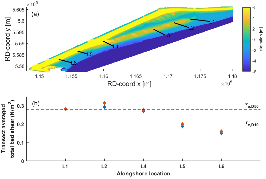 Figure 1: Positions of cross-shore arrays and local morphology (a). Averaged total bed shear stress for the different (b) The dashed horizontal lines indicate the critical bed shear stress for erosion for D10 and D50.
Results
Our results indicate that waves are locally generated and scale with wind speed and direction. The sheltering effect by a harbour jetty accounts for most of the alongshore variability. The current magnitude also decreases with proximity to the jetty. Consequently, alongshore variation in bed shear stresses are observed (fig. 1b) leading to alongshore sediment entrainment gradients.
References
HHNK and Witteveen+Bos, “Prins Hendrikzanddijk: Morfologische studie,” 2016.
M. C. Buijsman and H. Ridderinkhof, “Long-term ferry-ADCP observations of tidal currents in the Marsdiep inlet,” J. Sea Res., vol. 57, no. 4, pp. 237–256, 2007, doi: 10.1016/j.seares.2006.11.004.
Huisman, B. J., de Schipper, M. A. & Ruessink, B. G. (2016), ‘Sediment sorting at the Sand Motor at storm and annual time scales’, Marine Geology 381, 209–226.
I. Surname1*, F.N. Another-Surname2 , Y. Next-Surname2
1 University Name, Country; 2 Organization Name, Country
* Corresponding author: mail.name@organization.org
