B.T. Grasmeijer1,2*, B. Huisman2
1 Utrecht University
2 Deltares
*corresponding author:
Introduction
The open Dutch coast consists of sandy beaches, which are continuously changing as a result of wave-driven longshore transport, tide-driven transports and sea level rise. Sand nourishments are placed at regular intervals to maintain the position of the coastline and compensate any deficits in the sediment balance. A re-evaluation of the sediment balance is very relevant, as the last effort was undertaken decades ago by Van Rijn (1997).
This study uses the yearly bathymetric surveys of the Dutch coast as measured by Rijkswaterstaat (referred to as the 'Jaarlijkse Kustmetingen' or JarKus) from 1965 till the present day. These data consist of cross-shore transects with a 250 meter alongshore spacing for the nearshore area. The offshore section is measured five-yearly up to 3 km offshore with an alongshore spacing of 1 km, also referred to as 'doorlodingen'.
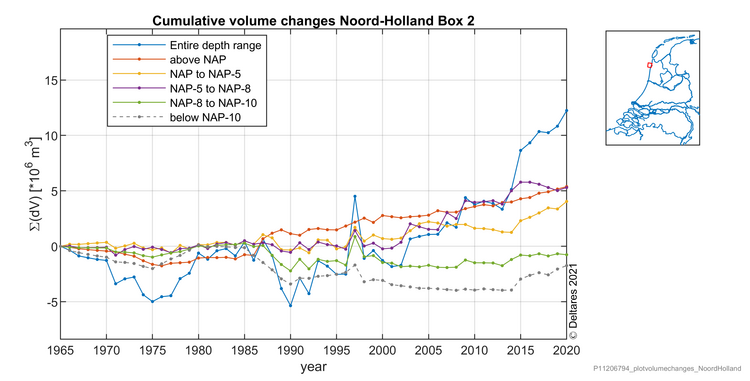
Figure 1: Example of cumulative volume changes in a box along the Noord-Holland coast
Method and results
Building on the work of Van Rijn (1997), we made a sediment budget model for the Noord-Holland coast by interpolating the cross-shore JarKus profiles in time and space on a regularly spaced grid to assess the sediment volume changes and trends per depth range over the past decades. Analyses were made for various depth-ranges and alongshore regions, which gives us a prime insight in the cross-shore influence zone of the nourishment program and general cross-shore behaviour of nourishments. Figure 1 shows an example of volume changes per depth range.
The results for the nearshore zone show the relevance of beach and shoreface nourishments for the preservation of the North-Holland coast, which generally is accretive. Erosive trends are observed typically in the more seaward section of the profile beyond 8 meter water depth. The observed sediment volume changes here are to be further interpreted in relation to transport computations by Grasmeijer et al. (2022), which gives us insight in expected future development of the region. Our study does not only quantify trends, but also explores a methodology for combining data sources in a sediment balance.
Van Rijn, L. C. (1997). Sediment transport and budget of the central coastal zone of Holland. Coastal Engineering, 32(1), 61–90. https://doi.org/10.1016/S0378-3839(97)00021-5
Grasmeijer, B., Huisman, B., Luijendijk, A., Schrijvershof, R., van der Werf, J., Zijl, F., … de Vries, W. (2022). Modelling of annual sand transports at the Dutch lower shoreface. Ocean & Coastal Management, 217(December 2021), 105984. https://doi.org/10.1016/j.ocecoaman.2021.105984
I. Surname1*, F.N. Another-Surname2 , Y. Next-Surname2
1 University Name, Country; 2 Organization Name, Country
* Corresponding author: mail.name@organization.org
