Gerben Ruessink1*, Bas Arens2, Marieke Kuipers3
1 Utrecht University
2 Bureau for Beach and Dune Research
3 PWN Drinking Water Company
*Corresponding author:
Introduction
Many foredunes along developed coasts have been managed into densely vegetated, uniform and stable ridges of sand to strengthen their role as sea defence. It is increasingly feared that such foredunes are less resilient to erosion under climate change (e.g., rising sea levels) relative to present-day conditions. The dense vegetation blocks the sand exchange between the beach and the backdunes and accordingly, prevents the backdunes from growing with sea-level rise. The excavation of gaps through the foredune, termed notches, is nowadays increasingly applied as a nature-based solution to restore the natural sand pathway into the backdunes and to improve their natural values with the overarching aim of advancing climate adaptation. The geomorphological evolution of notches is, however, not well understood, especially on the time scales of years. This prevents understanding what factors contribute to success (long-term mobility) or failure (rapid closure) of foredune notches.
Methods
We analyse the geomorphic evolution of five notches in the foredune near Bloemendaal - one of the largest dune restoration projects in NW Europe - since their excavation in the 2012/2013 winter using 24 digital elevation models (DEMs) derived from airborne lidar and drone surveys. Nineteen of these DEMs are associated with an RGB orthomosaic.
Results
The orthomosaics and DEMs of Difference illustrate that up to 280-m long and more than 7-m thick depositional lobes formed landward of the notches, while the notches persistently eroded through alongshore widening and steepening of the lateral walls (Fig. 1). Both the deposition and erosion volume, computed inside the region bounded by the azure blue line in Fig. 1c, increased approximately linear with time (33,500 versus 17.500 m3/y). The larger deposition than erosion volume is due to the throughput of wind-blown beach sand, highlighting that the notches facilitated highly efficient onshore sand pathways into the backdunes during the entire examined time period. In more detail, the data also suggest that the notches oriented with the dominant wind direction (the upper two notches in Fig. 1) were more efficient in facilitating this onshore transport than notches with other orientations.
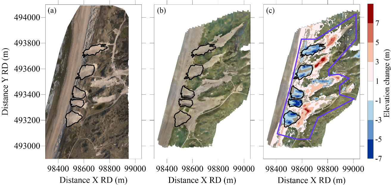
Figure 1: Orthomosaic (a) shortly after excavation (May 2013) and (b) after 8.5 years (October 2021), (c) and the DEM of Difference for the same time period (red = deposition; blue = erosion) overlain on the October 2021 orthomosaic. Black lines in all panels are the initial (May 2013) notch outlines. The azure blue line in (c) outlines the region for which erosion and deposition volumes were computed.
I. Surname1*, F.N. Another-Surname2 , Y. Next-Surname2
1 University Name, Country; 2 Organization Name, Country
* Corresponding author: mail.name@organization.org
