Rutger W.A. Siemes1*, Trang Minh Duong1, Bas W. Borsje1, Suzanne J.M.H. Hulscher1
1 University of Twente
*corresponding author:
Introduction
Estuarine regions are at the interface between rivers and seas. To allow shipping, and to ensure safety from flooding and freshwater availability, estuaries worldwide undergo many anthropogenic changes. Human interventions are desired to improve the current system and prepare for future threats, such as sea-level rise or sediment starvation. However, there is limited knowledge on the impact of large-scale human interventions on the development of the entire estuarine system. In this study, the aim is to explore the short-term (1 year), morphological response of estuaries to two large-scale intervention, and their impact on each other: 1) inter-tidal land reclamation, a nature-based solution increasingly recognised for its potential for flood safety, sediment trapping and ecosystem services (Temmerman et al., 2013) and; 2) Channel deepening, an intervention often applied within estuaries, e.g. to allow larger ships to enter the ports. To this end, an idealised morphological model is developed. In addition, by developing and applying a novel, generic approach to assess vegetation changes, the study aims to also gain insight into trends for vegetation development within the inter-tidal zone.
Methods
An idealised morphological model is developed in Delft3D-FM (2DH), representing a part of the Rhine-Meuse Delta (RMD), consisting of a coastal zone and estuarine channel (Figure 1). Firstly, the model is calibrated and validated to gain confidence in its ability to represent the RMD system. Next, large-scale interventions are implemented. Land-reclamation is implemented by creating vegetated intertidal zones. Hereby, a global dataset of salt marsh extent (Balke et al., 2016) is used to determine the area of the inter-tidal zone suitable for vegetation. Channel deepening is implemented (but also undeepening of the channel) by a uniform change in channel depth. Model simulations are performed using hydrodynamics for a representative year, including tides, seasonally varying waves and river discharge, to assess how these interventions affect short-term (eco-)morphological development of the estuarine system.
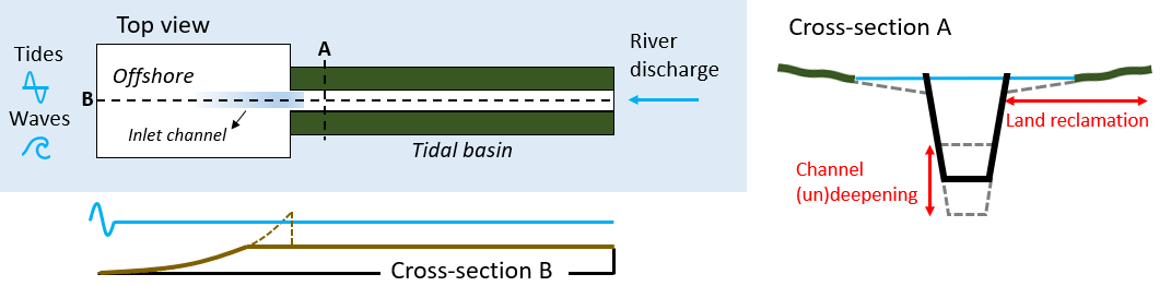
Figure 1: Graphical representation of the idealised estuarine model and the human interventions implemented within the model. The model is forced with tides and seasonally varying waves at the coast, and by a seasonally varying river discharge at the river boundary.
Results
The model is validated with observed hydrodynamic timeseries (water levels and waves) and observed annual morphological trends. Large-scale interventions are implemented, first in isolation and after that in combination. This way, the model helps us 1) to identify the (eco-)morphological impact of both types of interventions, locally and on the estuarine scale, and 2) to arrive at management strategies on how to deal with these large-scale human interventions in the RMD system.
References
Temmerman, S., Meire, P., Bouma, T. J., Herman, P. M., Ysebaert, T., & De Vriend, H. J. (2013). Ecosystem-based coastal defence in the face of global change. Nature, 504(7478), 79-83.
Balke, T., Stock, M., Jensen, K., Bouma, T. J., & Kleyer, M. (2016). A global analysis of the seaward salt marsh extent: The importance of tidal range. Water Resources Research, 52(5), 3775-3786.
I. Surname1*, F.N. Another-Surname2 , Y. Next-Surname2
1 University Name, Country; 2 Organization Name, Country
* Corresponding author: mail.name@organization.org
