B. Aschenneller¹*, R. Rietbroek¹, D. van der Wal¹·²
¹ Faculty of Geo-Information Science and Earth Observation (ITC), University of Twente, PO Box 217, 7500 AE Enschede, the Netherlands
² NIOZ Royal Netherlands Institute for Sea Research, Department of Estuarine and Delta systems, PO Box 140, 4400 AC Yerseke, the Netherlands
*corresponding author:
Introduction
Coastline migration can have several causes with one of them being increased or decreased inundation due to changes in absolute sea level. A second factor are vertical land movements, e.g. subsidence due to the extraction of ground material or uplift as a delayed response to the last ice age, leading to changes in relative sea level and therefore also influencing the extent of inundated areas. Apart from these geometrical effects, morphological processes including those resulting from human intervention are influencing the position of a coastline. Changes in relative sea level height can additionally alter the morphodynamic response. Coastal zones, and particularly their coastlines, are therefore influenced by a combination of absolute sea level changes, vertical land movements and morphological changes.
Methods
We are investigating ways to separate these three groups of influences on changes in coastal geometry from each other. For this, we will analyse coastal sea-level heights from multi-mission radar altimetry in combination with other height datasets like tide gauge measurements, GNSS observations and land elevation data from LiDAR airborne surveys and bathymetry from shipborne multibeam and single beam surveys. We aim at resolving vertical land motion by combining these datasets. Series of snapshots of coastal land-water interfaces will be extracted from optical remote sensing images using Sentinel-2 and Landsat data. Add a sentence about the combination.
Results
In this contribution, we will show preliminary results and perspectives for a case study for the barrier island Terschelling (the Netherlands). First, we will show an accuracy assessment of the retracked altimetry products. With the GNSS observations it will be possible to compare sea-level heights from altimetry with tide gauge measurements, which will help us to quantify sea-level changes in the vicinity of the coast. Furthermore, we will investigate how well the optical remote sensing images used for coastline extractions can be matched with the passes from radar altimeters in time and space. In future research, comparison of coastlines extracted from images with coastlines obtained from topographic heights can give us insight into coastline changing processes.
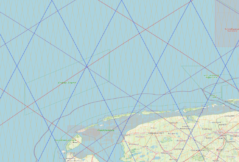
Figure 1: Altimetry ground tracks in the study area. Red: Jason-1, -2, -3 and Topex/Poseidon (reference orbit). Purple: Jason-1 and Topex/Poseidon (interlaced tracks). Blue: Envisat. Yellow: CryoSat-2. Source: TU Delft RADS database.
I. Surname1*, F.N. Another-Surname2 , Y. Next-Surname2
1 University Name, Country; 2 Organization Name, Country
* Corresponding author: mail.name@organization.org
