
Otto S. R. Ongkosongo1*
1 National Water Resources Council (DSDAN) of Indonesia
*corresponding author: This email address is being protected from spambots. You need JavaScript enabled to view it.; +62 81312942040;
Introduction
During the last century, there has been a quite reverse difference on the relative stability condition of the most parts of the flat North coast of Java, Indonesia. Until about the decade of 1960-1970 most of the coasts are in accretion stage. More particularly in the flat low-lying muddy sand to sandy mud coasts, the coasts are flourished occupied by dense mangrove belt. After the independence of Indonesia in 1945, there has been fast increasing of urbanization. Except in Jakarta, Semarang, and Surabaya, and around the existing small ports, people are rare to live on and near the coastline. Some villages are also built started on old and new beach ridge coast, near or relatively rather far. From East to West, the flat coasts are separated in parts by protruding land and higher elevation of rocky land. These have resulted as pocket mangrove beach ridge and chenier coasts as part of deltaic system, as well as many protruding dynamic small deltas. with the longest flat coastline located in between Batang-Pekalongan-Tegal-Cirebon-Jakarta-and Bojonegara. Although not too many in number, some people occupying and changing intensively the mangrove swamp environment into fish ponding, leaving bare or very thin layer of mangrove belt on the shorelines. In the unique Citarum delta complex, as example, the land use conversion has been started before 1900. Since the 1970's, however, there are continuing and intensive ground water extraction to support water consumption of the very dense and fast growth populated areas in the immature coastal plain along the North coast. Mangroves are still depleted, in addition to those which are intensively eroded by waves, and fishponds are also continuously operated, although many others are abandoned. Intensive daily transportation has also been subsequently sinking the soft formed delta plains. As drastic results, most coasts in fast subsidence and most parts of the coastlines are severely eroded (Figure 1), and very ugly. Thousands ha of land has been lost, becoming more frequently inundated during high rainfall, which persistently troublesome many people.
Methods
The flow of the study method can be simplified in Figure 1 as the following.
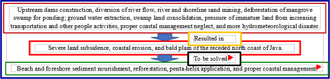
Figure 1. Simplified causal-effect scheme of the discussed paper.
Results
This paper hence proposes and begging the government, supported by other disaster penta-helix components, to be more aware, effective, and participative in solving this serious acute problem, through the following cheaper problem solving. First, the coast must be intensively and quickly nourished by pumping sediments from the adjacent sea bottom of the most critical land with more economical value. Second, simultaneously the inundated and retreating land must be massively reforested and regreened with right vegetation (particularly mangrove) species, right planting method, and right location. The hard solution by structure construction may be applied in very critical and densely populated areas, as well as location of important infrastructures like port, electric power station, and industry centres. The use of rock gravels look likely in most parts is better than using the massive reinforced concrete due to more environmentally friendly. A new rapid integral study should be done to support the present available projects and thorough studies from various players, to solve the problem rapidly and incrementally in more local and by local way in a proper sustainable coastal management.