A. de Bakker1*, P. Tonnon1, C. Lescoulier2, N. Guillot2, D. Roelvink13, C. Lequette2 and R. Carrel2
1 Deltares, Delft, the Netherlands; 2 Egis-Eau, Montpellier, France, 3 IHE Institute for Water Education, Delft, the Netherlands;
*corresponding author:
Introduction
The Senegal river delta is vulnerable to inundation during the rainy season. To avoid widespread inundation in 2003 of the region's capital city Saint-Louis (UNESCO-heritage site), the authorities decided to expel the surplus of river water by creating an artificial breach 7 km south of the city, through the Langue de Barbarie sand spit (Figure 1). This avoided large-scale inundations of the city, but the artificial breach grew uncontrollably during the subsequent years and became the new river mouth. This altered the dynamics of the lower river delta and continuous to affect local villages, fishery activities, agriculture, and nature reserves. With the natural southward migration of the river mouth at a pace of ~500 m/yr, the population subject to flood risk by 2050 is estimated at 178,300 inhabitants for a 100-year flood. The Government of Senegal has asked the consortium Egis Eau - Deltares to propose a sustainable and long-term management strategy for the lower Senegal river delta. Here, the project approach and results are presented.
Methods
During the project, in-depth technical analyses were integrated with social, economic, financial and environmental analyses. To understand the natural system in detail, at the start of the project extensive measurement campaigns were realized. High-resolution bathymetry and topography were acquired, together with information on physical processes such as water level variations, currents, waves and salinity levels in the river. Various numerical (morpho)dynamic models of river- and coastal dynamics were developed and calibrated with the newly acquired field data, to evaluate various scenario's and help in the preparation of an intervention plan.
Results
It is recommended to maintain the natural functioning of the lower delta, while attenuating the negative impact of the southward migrating river mouth. To avoid inundation of Saint-Louis after horizon 2050, whenever a peak (> 1/10-year return period) river discharge is measured upstream at the hydrological station of Bakel, an artificial breach should be created through the sand-spit a few kilometers south of the town of Degouniaye (23 km south of Saint-Louis). This ensures protection against flooding of Saint-Louis up to a 100-year flood level by the year 2100, without large-scale negative impacts. In addition, a package of urgent "no-regret" protection measures is recommended.
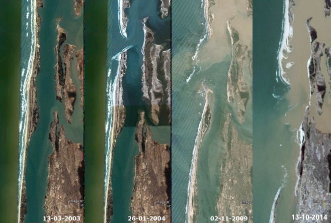
Figure 1: The Langue de Barbarie sandspit in Senegal just before, and the years following, the creation of the artificial breach (Source: Google Earth).
I. Surname1*, F.N. Another-Surname2 , Y. Next-Surname2
1 University Name, Country; 2 Organization Name, Country
* Corresponding author: mail.name@organization.org
