D.E. Hartmann*, S.M. de Jong, M. Gravey, T.D. Price
Utrecht University
*corresponding author:
Introduction
Accurate measurements of coastal water depths (i.e. near-shore bathymetry) are of fundamental importance for studying coastal hazards, changes in benthic habitats and sea level rise. Despite its importance, a lack of bathymetric information exists for most coastal regions in the world. The conventional method of mapping bathymetry, ship-sounding, is costly and inefficient. Satellite imagery provides a potential alternative for estimating bathymetry at large spatial and temporal scales, especially with recent advances in temporal, spatial and spectral image resolution. Such methods are limited to clear waters, through which the seabed is directly visible. Here, we apply machine learning to multispectral and hyperspectral satellite imagery, and present approaches to estimate near-shore bathymetry from the continental shelf of Puerto Rico.
Methods
This research employed 296 atmospherically corrected Sentinel-2 reflectance images, and three hyperspectral PRISMA images. Three methods were used to derive near-shore bathymetry: an empirical method with the green and blue spectral bands from Stumpf et al. (2003), an XGBoost machine learning model using all spectral bands, and an empirical method using hyperspectral imagery from Ma et al. (2013) using 16 spectral bands in the blue and green spectrum. The variance of each depth prediction was calculated to assess its certainty.
Results
The XGBoost model showed an error of up to 1.05 m for depths up to 20 m (Figure 1). The empirical method with hyperspectral imagery had a mean absolute error of 1.23 m in the same area. Over the entire study area, the XGBoost model had a mean absolute error of 1.64 m, which was 34% better than the empirical model from Stumpf (2003). Areas with high variances were found to be influenced by periodic sediment flows in the water, which reduced the model's performance. Further results are expected from the use of artificial neural networks applied to the images, which we will show at the conference.
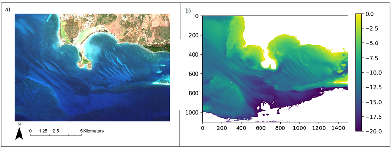
Figure 1: Plots of the median RGB image (a) and predicted depth in meters by XGBoost model (b) of the study area.
References
Ma, S., Tao, Z., Yang, X., Yu, Y., Zhou, X., & Li, Z. (2013). Bathymetry retrieval from hyperspectral remote sensing data in optical-shallow water. IEEE Transactions on Geoscience and Remote Sensing, 52(2), 1205-1212.
Stumpf, R. P., Holderied, K., & Sinclair, M. (2003). Determination of water depth with high‐resolution satellite imagery over variable bottom types. (1part2), 547-556.
I. Surname1*, F.N. Another-Surname2 , Y. Next-Surname2
1 University Name, Country; 2 Organization Name, Country
* Corresponding author: mail.name@organization.org
