J. Bootsma1,2*, B.W. Borsje1, D. van der Wal1,2, S.J.M.H. Hulscher1
1 University of Twente; 2 NIOZ
*corresponding author:
Introduction
Intertidal areas in estuaries are often inhabited by vegetation, which plays a crucial role in shaping these ecosystems and providing valuable ecosystem services. It is essential to understand how intertidal vegetation responds to changes in sea level, river discharge and salinity induced by climate change or anthropogenic influence, to determine the effect on its ecosystem services. Furthermore, while nature-based solutions are receiving attention for the sake of coastal safety, these solutions are understudied for the mitigation of salt intrusion.
Approach
A combination of available data from field surveys, remote sensing, and modelling techniques will be applied to identify the potential of vegetated intertidal areas, both fringing as mid-channel flats, as nature-based solutions to mitigate salt intrusion. Vegetated intertidal areas located in salt, brackish and freshwater regions in the Scheldt estuary, from the mouth near Vlissingen, the Netherlands, till Gent, Belgium are used as study areas in this project. In the first phase, the distribution of estuarine intertidal vegetation over the past 30 years will be studied using remote sensing techniques and available data from field surveys. In phase two, the vegetation distribution will be linked to a level of salinity to obtain response curves. An expected vegetation distribution can then be obtained by coupling these curves with future scenarios for salt intrusion. Shifts in vegetation distribution will alter hydrodynamics, sediment dynamics and therefore bed level dynamics, ultimately influencing the ecosystem services by vegetated intertidal areas. Therefore, the third phase comprises a full biogeomorphological analysis of the development of vegetated intertidal areas, forced by changes in salinity, sea level and river discharges. By combining insights from the first three phases, the final phase investigates the potential of vegetated intertidal areas as nature-based solution to mitigate salt intrusion.
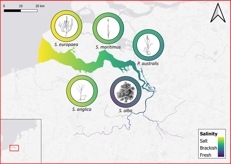
Figure 1: A schematic representation of the Scheldt estuary, showing its salinity distribution and the presence of the five vegetation species at their typical salinity. The illustrations of the vegetation species are not to scale. Salinity data from (Breine et al., 2008). Vegetation illustration courtesy of Lizzie Harper and Botanical-online.
References
Breine, J., Maes, J., Stevens, M., Simoens, I., Elliott, M., Hemingway, K., & Van den Bergh, E. (2008). Water management strategies for estuarine and transitional waters in the North Sea Region . HARBASINS : Harmonised River Basin Strategies North Sea Habitat needs to realise conservation goals for fish in estuaries : case study of the tidal Schelde. Rapport van het instituut voor Natuur- en Bosonderzoek.
I. Surname1*, F.N. Another-Surname2 , Y. Next-Surname2
1 University Name, Country; 2 Organization Name, Country
* Corresponding author: mail.name@organization.org
