R. Houthuys1*, A. Dujardin2, T. Verwaest3
1 Geoconsultant; 2 Antea Group Belgium; 3 Flanders Hydraulics
*corresponding author:
Introduction
A coastal morphological analysis (Houthuys et al., 2022) has been conducted on high-resolution surveys of the Belgian coastal zone, spanning the dune front or seawall area down to the nearshore channels and sandbanks up to 1500 m offshore. In the MOZES project (Dujardin et al., 2023), bathymetric charts of a mid-1980s survey covering the nearshore and inner shelf zone (up to ca. 12.000 m offshore) have been digitized and compared to a recent survey of the same area (Figure 1).
Methods
LIDAR data of the area above low water are available at a (semi-)annual interval since 1999. Below low water mainly single-beam echo soundings are used; multi-beam data becomes more frequent since 2007. Time series of sand volumes have been computed per coastal stretch. They have been corrected for artificial removal by dredging or sand borrowing and supply by nourishments. Volume changes have been studied in their spatial context.
Results
Flow channels flank much of the Belgian beaches. It is observed that they have deepened over time. It is hypothesized that the tidal flow in the channels is subject to squeeze: the shallow sandbanks at the seaward side are under the presently slowly rising sea levels migrating shorewards, while the coast is kept at its location, and even expanded seaward, by nourishment. As a result, these channels can only maintain their flow section by eroding their bed. The nearshore sandbanks do migrate, with rates of a few m/yr in the landward and a few tens of m/yr in the eastward direction. These conclusions will be further substantiated within the MOZES project, using more inner shelf zone surveys.
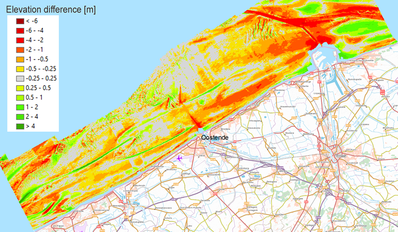
Figure 1: Elevation difference map of the overlap area between the 1984/7 and the 2022 bathymetric maps.
References
Houthuys, R.; Verwaest, T.; Dan, S. (2022). Morfologische evolutie van de Vlaamse kust tot 2019: Evolutie van de Vlaamse kust tot 2019. Versie 2.0. WL Rapporten, 18_142_1. Waterbouwkundig Laboratorium: Antwerpen
Dujardin, A.; Houthuys, R.; Nnafie, A.; Röbke, B; van der Werf, J.; de Swart, H.E.; Biernaux, V.; De Maerschalck, B.; Dan, S.; Verwaest, T. (2023). MOZES - Research on the Morphological Interaction between the Sea bottom and the Belgian Coastline: Sub report 1 – Working year 1. FH Reports, 20_079_1. Flanders Hydraulics: Antwerp.
I. Surname1*, F.N. Another-Surname2 , Y. Next-Surname2
1 University Name, Country; 2 Organization Name, Country
* Corresponding author: mail.name@organization.org
