
A. Leone1,2, A. Grilli1, D. Roelvink2,3, J. Reyns2,3
1 University of Rhode Island; 2 Deltares; 3 IHE Delft Institute for Water Education
Shoreline recession associated to sea level rise (SLR) or other anthropogenically induced factors presents an increasing threat to coastal communities around the world. When the nearshore area is a barrier beach, the threat is particularly insidious, gradually destroying the first line of protection of the landward community. The Southern Rhode Island (RI) shoreline is formed of a sequence of beach barrier systems protecting the landward communities. In the present study, we focus on the long-term dynamics of two beach barrier systems, the Napatree Point, an undeveloped flying spit that has been stable since 1975, and the rapidly recessing Ninigret-Trustom Ponds (NTP) barrier beach, partially urbanized and open to Block Island Sound by a stabilized inlet. The objectives of the study were: (1) simulating the observed shoreline changes at the two study sites using the 1-D shoreline model, ShorelineS (Roelvink et al., 2020); (2) predicting the long-term changes in shoreline position at both sites for the next decades; (3) understanding and explaining the contrasting morphodynamics observed at the two sites. The version of ShorelineS used in the simulations predicted changes in shoreline positions based on the combination of a longshore transport term and a sea level rise term. The cross- shore transport is neglected based on the assumption that this term mostly represents the interannual variability and would balance itself at the decadal scale, resulting in no significant net cross-shore transport. ShorelineS was calibrated and validated at each site based on historical observations from previous studies (Oakley, 2021). The model accurately reproduced the stable planform shape observed in Napatree Point from 1985 to 2014 using local wave climate data and SLR values in input. Based on these results, the model was used to predict the shoreline positions over the next 50 years. Long-term projections of the shoreline at Napatree predicted a slow recession with a shrinking in the width of the barrier. However, when used at the NTP site, the model strongly underestimated the observed shoreline recession. This site, being more urbanized than Napatree, shows significant portions of the dune strongly depleted with low-crest and over-washed by the seasonal winter Nor'easters. It was determined that the cross-shore transport and overwash could not be neglected and should be used in future simulations. However, the simulations enlighten the physical processes explaining the divergent behaviours at the two study sites: the stable crescent shape of Napatree Point is controlled by the longshore current shifting from eastward with sediments trapped and conserved in the crescent shape system. Contrastingly, the NTP site is characterized by a dramatic loss of sediments, neither explained by the longshore current or the SLR, pointing to dynamics predominantly caused by storm-induced cross-shore transport.
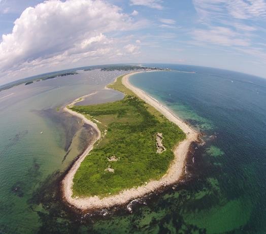
Figure 1: Napatree spit, Westerly RI (image courtesy: Ferguson, 2022).
References
Roelvink, D., Huisman, B., Elghandour, A., Ghoim, M., Reyns, J. (2020). Efficient modeling of complex coastal evolution at monthly to century time scales. Front. Mar. Sci.
Oakley, B. (2021). Storm Driven Migration of Napatree Barrier Rhode Island, USA. Geosciences
I. Surname1*, F.N. Another-Surname2 , Y. Next-Surname2
1 University Name, Country; 2 Organization Name, Country
* Corresponding author: mail.name@organization.org
