N.D. Volp1,2, O. Baltus1, R. Gijsman2, E.M. Horstman2, M. Siemerink1, P.C. Roos2
1 Nelen & Schuurmans; 2 University of Twente
*corresponding author:
Introduction
Coastal areas around the world can be characterised based on the occurring vegetation. Vegetation varies strongly at small scale (O(1m)), but it has an effect on the currents and the waves at a much larger scale (O(500m)). These areas are not only characterised by strong vegetation variations, but also by strong bathymetry variations. However, to take these small-scale features into account in hydrodynamical models covering an estuary can be computationally costly. We propose a method that can take these small-scale effects into account, while keeping the computational times short.
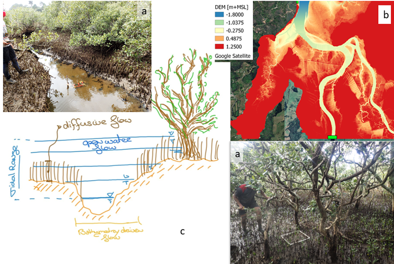
Figure 1: a) Impressions of the mangrove forest area of the Whitianga Estuary (Horstman et al. (2021)) b. The bathymetry of the study areas (O. Baltus, 2022) c) Sketch for modelling the types of flow in different layers.
Methods & Results
Vegetation affects the vertical flow structure. The presence of vegetation alters the familiar logarithmic flow profile, known from flow over a rough bottom. Especially, in case of dense vegetation, the flow through the vegetation is uniform. For larger water depths and less dense vegetation, the flow structure re-establishes the familiar flow profile, although affected by a vertical drag. In areas where the vegetation is dense, the bathymetry height is difficult to measure, and is known to have large uncertainties. However, in areas with a more open coverage, the bathymetric variations become very important for the flow behaviour. We propose a depth-averaged, two-layer approach for modelling densely vegetated areas in large scale models. The bottom layer describes the diffuse flow through the dense layer of vegetation. The upper layer accounts for the bathymetric, roughness and a newly derived method for vegetation variations at high resolution, using a so-called subgrid-method (Volp et al. 2013). We will introduce the method and test it based on an application of a mangrove forest in the Whitianga Estuary.
References
Horstman, E. M., Bryan, K. R. & Mullarney, J. C. (2021). Drag variations, tidal asymmetry and tidal range changes in a mangrove creek system. Earth Surface Processes and Landforms, 46(9), 1828–1846. https://doi.org/10.1002/esp.5124
Volp, N. D., Van Prooijen, B. C. & Stelling, G. S. (2013). A finite volume approach for shallow water flow accounting for high-resolution bathymetry and roughness data. Water Resources Research, 49(7), 4126–4135. https://doi.org/10.1002/wrcr.20324
Baltus, O., Representing spatially variable bathymetry and vegetation in a hydrodynamic model: A subgrid-based case study in the Whitianga Estuary, New Zealand, M.Sc. thesis 2022.
I. Surname1*, F.N. Another-Surname2 , Y. Next-Surname2
1 University Name, Country; 2 Organization Name, Country
* Corresponding author: mail.name@organization.org
