Y. Attema1*, B. van Leeuwen1, A. Kroon1,2
1 Svašek Hydraulics; 2 Delft University of Technology
*Corresponding author:
Introduction
Many of our coastlines are curved and therefore storm erosion likely originates from both alongshore and cross-shore processes. In the national program BOI (Assessment and Design Instrument for flood defences) a new instrument for dune safety assessments is being developed based on the XBeach modelling software. The methodology within this instrument includes a 1D XBeach approach at present. However, a 2D approach is more suitable for complex coastal sections. At this moment the instrument for the 1D XBeach approach is being rolled out, while the 2D approach still needs to be developed. In anticipation of these developments, this study investigates the importance of a 2D approach compared to a 1D approach with an eminently suitable dune erosion case study at the strongly curved sandy sea defence of Maasvlakte II. In this case study XBeach is utilized to reproduce the measured dune erosion up to 80 m3/m at Maasvlakte II due to the winter storms at the start of 2022.
Methods
Firstly, the detailed topographical measurements taken in Q4 of 2021 before the storms and in Q1 after the storms of 2022 are analysed and quantified to learn more about the dune erosion patterns along the Maasvlakte II. Subsequently, to investigate the importance of a 1D or 2D approach the dune erosion measurements are compared with the 1D and 2D XBeach BOI model results. The XBeach model of Maasvlakte II is setup to simulate the dune erosion over a period of 130 days between the measurements. The XBeach model is applied in 1D and 2D surfbeat mode. For the 2D model, a curvilinear grid is used with cells measuring 2.5x25 m (cross- x longshore) in the area of interest, whereas the 1D model is based on specific transects of this 2D model. Both models have been set-up with wave climate reduction techniques and a morphological acceleration factor to speed up the simulations.
Results
The results show that significant differences in the amount of dune erosion occur between a 1D and 2D XBeach model approach at strongly curved coastal sections such as transect a), see top panel in figure 1. The results at straight coastal sections are more similar between the two approaches, see transects b) and c). Furthermore, it was found that the default settings from the XBeach BOI version are able to accurately model the dune erosion, see bottom panel in figure 1. It should be noted that after the winter storms of 2022 a nourishment has been placed on the beach, therefore significant difference are observed below 3 m+NAP, nonetheless the erosion above 3 m+NAP is represented accurately.
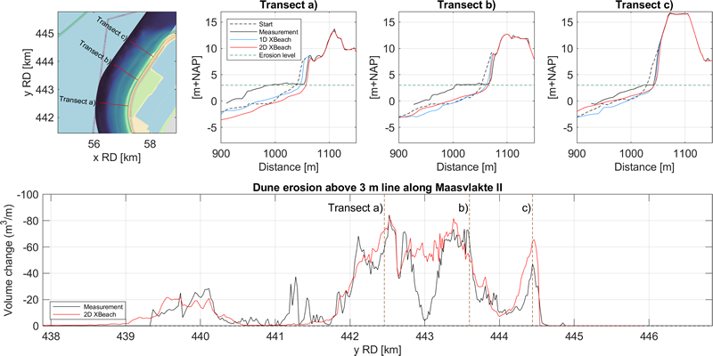
Figure 1. A comparison of meaured (Black) and modelled 1D (Blue) and 2D (Red) dune erosion.
These results suggest that 2D effects on the dune erosion are important at strongly curved coastlines and that the 2D XBeach model with BOI settings is able to accurately model dune erosion at Maasvlakte II.
I. Surname1*, F.N. Another-Surname2 , Y. Next-Surname2
1 University Name, Country; 2 Organization Name, Country
* Corresponding author: mail.name@organization.org
