
J.W. Bosma1*, T.D. Price1, M.A. van der Lugt2,3, M.A. de Schipper2, B.G. Ruessink1
1 Utrecht University; 2 Delft University of Technology; 3 Deltares
*corresponding author:
Introduction
Sand nourishments have become an increasingly popular alternative to the traditional rigid (or 'grey') flood defences made of concrete, asphalt and stones. Our predictive understanding of how coastal nourishments evolve stems from wave-dominated coasts, such as the exposed Holland coast (Huisman et al., 2019). In recent years, however, also existing flood defences in (semi-)enclosed regions have been upgraded with sandy foreshores (Perk et al., 2019). Here, the hydrodynamic boundary conditions are considerably different from the open coast, and coarser sand is often used to minimise erosion and account for the lack of natural supply. Accordingly, this work aims to characterise the morphologic development of such an artificial beach in a semi-enclosed system by linking it to the interplay between grain-size sorting and hydrodynamics.
Study site and methods
We focus on the Prins Hendrikzanddijk, an artificial sandy foreshore on the mainland (or Wadden Sea) side of the barrier island of Texel (Perk et al., 2019; Fig. 1), completed in 2019 and featuring a man-made spit. The nourished sediment is very mixed and in general much coarser than the native sediment (700 µm v. 200 µm). Long-term monitoring (2-3 month return period) of bed levels and grain sizes, and measurements of waves and currents during a dedicated field campaign (5 weeks) have resulted in an extensive dataset (which continues to grow).
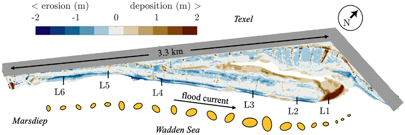
Figure 1: Bed-level change at the Prins Hendrikzanddijk in the first 3 years after construction and a schematic representation of the longshore distribution of cross-shore mean intertidal grain size (D50 = 500-900 µm). The black hatched area indicates the location of the old Prins Hendrikdijk.
Results
In the first four years after completion, net erosion of the upstream intertidal areas (dark blue strokes, Fig. 1) acted as the sediment source for the extension of the spit (by tens of metres per year; NE of L1) due to continuous accretion of relatively fine sediment (< 600 µm), resulting from persistent preferential entrainment by the dominant flood current. During storms, poorly sorted nourishment sand is stirred up from deeper layers and eroded from the upper beach to be delivered to the lower parts of the beach, refining the bed and suppressing the formation of clear large-scale sorting patterns. These developments are a consequence of design choices regarding profile shape and sediment type.
References
Huisman, B. J. A., Walstra, D. J. R., Radermacher, M., de Schipper, M. A., & Ruessink, B. G. (2019). Observations and Modelling of Shoreface Nourishment Behaviour. Journal of Marine Science and Engineering 2019, Vol. 7, Page 59, 7(3), 59. https://doi.org/10.3390/JMSE7030059
Perk, L., van Rijn, L., Koudstaal, K., & Fordeyn, J. (2019). A rational method for the design of sand dike/dune systems at sheltered sites; Wadden Sea Coast of Texel, The Netherlands. Journal of Marine Science and Engineering, 7(9). https://doi.org/10.3390/jmse7090324
I. Surname1*, F.N. Another-Surname2 , Y. Next-Surname2
1 University Name, Country; 2 Organization Name, Country
* Corresponding author: mail.name@organization.org
