
J.J. Naidoo1, H.M. Elmilady1, A. Colina Alonso2,4, A. Dastgheib1,3, M. van der Wegen1,2*
1 IHE Delft Institue for Water Education; 2 Deltares, 3 IMDC, 4 TU Delft
corresponding author:
Introduction
The estuarine intertidal zone provides a habitat for marine ecosystems, coastal protection against floods and behaves as a mechanism to control erosion (Elmilady, et al., 2022). However, climate change and anthropogenic pressure pose a threat to the deterioration of intertidal areas. An understanding of the system is essential to develop coastal management strategies ensuring sustainability of the system under sea level rise. In addition, little is known on the long-term morphodynamic evolution of intertidal area in the presence of both sand and mud (Colina Alonso, et al., 2020). This study aims to assess the morphodynamic development of sand-mud intertidal flats under sea level rise.
Methods
We base our research on published and validated morphodynamic Delft3D area models, to which we add different scenarios of SLR. These include schematized tidal basins comparable to Wadden Sea basins and a Western Scheldt case study. The behaviour and spatial distribution of the tidal flats are investigated under various sediment composition (i.e. sand /mud).
Results
Figure 1 and 2, depicts the cumulative intertidal area and the hypsometric curves with sand-mud interaction, for the schematized model of a tidal inlet, located in between two barrier islands replicating the Ameland inlet. The linear SLR imposed was 0.96m/100years and the modelled morphology starts from T = 100 years until T = 200 years. With sand-mud interaction, less intertidal area is lost as compared without interaction. Model results shows that intertidal area react with inertia to SLR where areas close to the sediment source (i.e. the mouth) adapt faster than areas more landward, so that intertidal areas will become flatter under SLR. Model results also suggest that intertidal flats will become muddier under SLR.
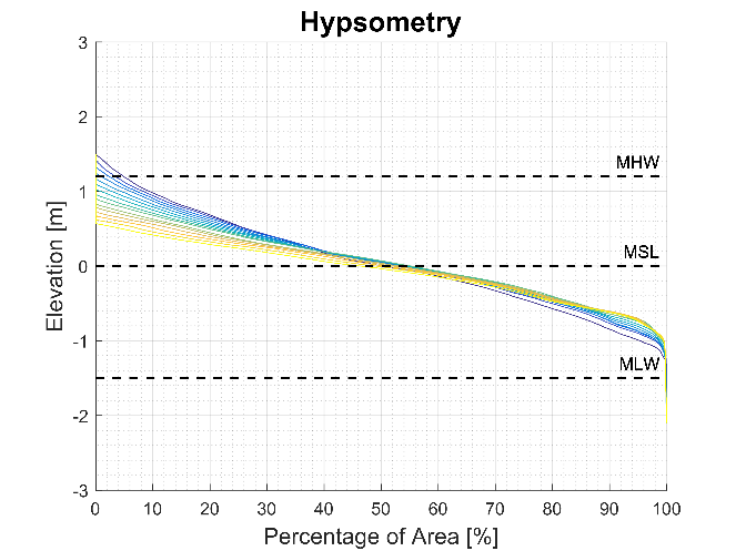
Figure 1: Cumulative intertidal area for linear SLR = 0.96m/100years. Red line indicates initial time step and yellow line indicates final time step.
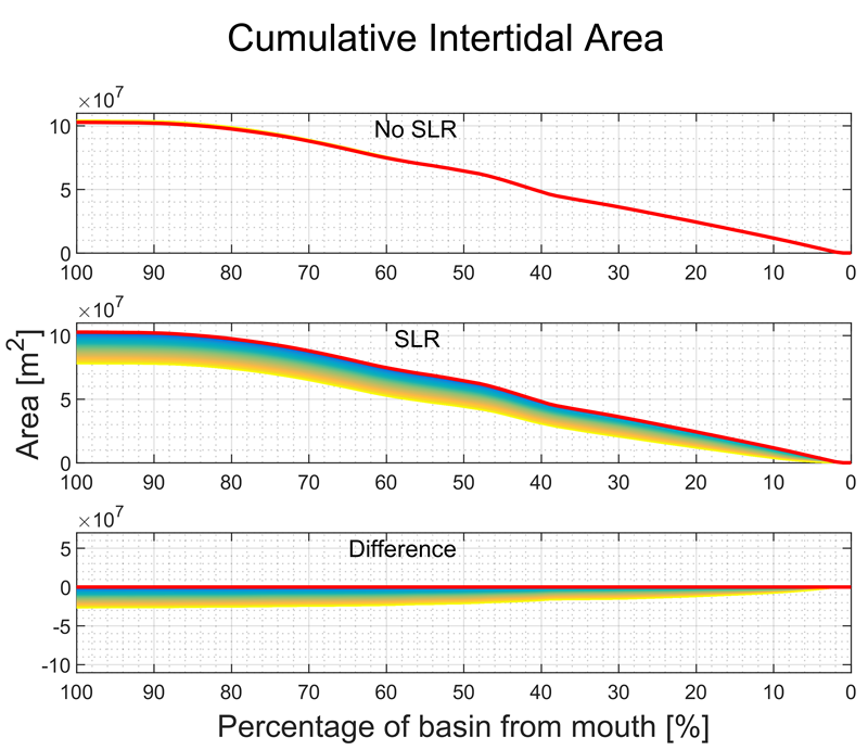
Figure 2: Hypsometry for linear SLR = 0.96m/100 years. Blue line indicates initial time step and yellow line indicates final time step.
References
Colina Alonso A, Weerdenburg Rv, Maren Bv, Huismans Y (2020) Modelling sand-mud interaction in Delft3D.Investigation of sand-mud modules in Delft3D and Delft3D-FM Deltares, Delft, The Netherlands, pp. 66.
Elmilady H, van der Wegen M, Roelvink D, van der Spek A (2022) Modeling the Morphodynamic Response of Estuarine Intertidal Shoals to Sea-Level Rise. Journal of Geophysical Research: Earth Surface 127: e2021JF006152 DOI https://doi.org/10.1029/2021JF006152
I. Surname1*, F.N. Another-Surname2 , Y. Next-Surname2
1 University Name, Country; 2 Organization Name, Country
* Corresponding author: mail.name@organization.org
