Thijs van Steen1, Brenda Walles1, Jaco de Smit1 & Wietse van de Lageweg1
1HZ University of Applied Sciences, the Netherlands; 2 Organization Name, Country
*Corresponding author: wietse.van.de.lageweg@hz.nl
Introduction
Coastal ecosystems such as oyster reefs, salt marshes and mangroves are widely recognised as nature-based solutions reducing coastal erosion. Oyster reefs maintain their own habitat and have the ability to grow at the rate of sea level rise, making them self-sustainable, flexible and cost-effective coastal erosion measures in the face of climate change. By attenuating waves and stabilising sediment as well as facilitating and protecting neighbouring ecosystems, they stimulate coastal resilience. However, effective employment of oyster reefs as a nature-based erosion control measure is not trivial and requires the integration of ecological and engineering parameters.
Recent work demonstrates that oyster reefs lead to a four-fold reduction in erosion in the protected area compared to a non-protected area across a decadal period. Despite this apparent effectiveness across a longer time period, it is still poorly understood how effective oyster reefs are in reducing erosion during individual storm events and how large their morphological footprint during these events is.
Objective and Methods
We present the findings of a series of detailed morphological field surveys of the Viane oyster reef (200m x 8m x 0.25m) in the Eastern Scheldt, the Netherlands, during which three storm events (Ciaran, Pia and Henk) were captured. These storms led locally to significant wave heights of 1.3-1.5 m, corresponding to the highest percentile of wave events recorded locally. Monthly surveys with a LEICA dGPS were performed to assess the elevation changes pre- and post these storm events along four transects. Three transects crossed the oyster reef (west, middle, east) and one served as a reference transect without an oyster reef. The transects aligned with Rijkswaterstaat RTK monitoring to allow for a comparison with the longer-term historical trends and had a total length of 500 meters.
Results
Results show that storm Ciaran resulted in a transect-average erosion of 0.02-0.05 m for the unprotected areas, corresponding to the typical annual erosion for the intertidal flats of this area. In contrast, the reef-protected areas showed a greatly reduced erosion of maximum 0.02 m but typically 0.01 m. It is important to note that the erosion pattern as a result of this storm event is far from homogeneous: erosion is greatest immediately behind the reef (~first 50 m), then reduces up to 150 m behind the reef, followed by a zone of deposition (150-250 m behind the reef) and then transitions into another zone of erosion (250-450 m behind the reef). Storms Pia and Henk had a notably smaller morphological effect on the Viane tidal flats, independent of the presence of the oyster reef. Although the maximum wave heights of these storms were of similar order of magnitude as observed for storm Ciaran, the wave directions were west rather than south. Complementary numerical modelling with XBeach will be used to obtain additional insights into the role of wave angle, wave period and tidal timing on the flow, sediment transport and morphological changes caused by the Viane reef structure during storm events.
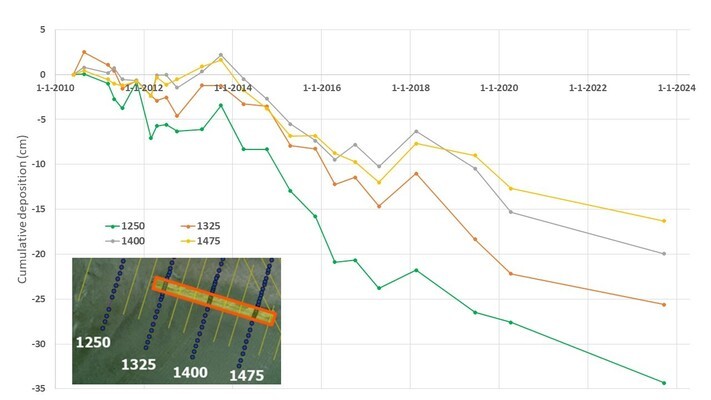
Figure 1. Cumulative deposition for four transects of the Viane (Eastern Scheldt) tidal flat with (transects 1325, 1400, 1475) and without (transect 1250) protection by an oyster reef during the period 2010 - 2023.
