A. Bolle1, B. Verheyen1, T. Vanagt2, H. Castro1, A. Breugem1, and A. Dastgheib1,3
1 IMDC, 2 ORG, 3 IHE Delft
* Corresponding author: annelies.bolle@imdc.be
Introduction
With Coastal Vision, the Flemish government has defined a strategy to keep protecting the coast on the long run, even up to 3 meter sea level rise. Starting point for this is the 2011 Master Plan for Coastal Safety which consists of a series of measures to protect Flanders’ coast against a 1000-year storm event until 2050, including 30 cm sea level rise. But in the future we need to do more, to make sure also the children of our grandchildren can keep enjoying our coast. Several alternatives have been studied, evaluated and compared, in order to select the most promising alternative.
At this moment the public consultations of the draft strategic policy plan are ongoing (see also www.kustvisie.be), allowing everyone to get insight in the plan, and how we got to the proposed alternative ‘Seaward’ for future coastal protection. The coastline will move on average about 100 m seaward, and dunes and dikes will be raised and widened to keep the hinterland dry when sea level rises. By keeping our beaches at least as wide as today, ‘Seaward’ offers space and opportunities for, among other things, experiencing nature, sports, recreation and the economy.
Objective and Methods
In order to define the preferred alternative, numerous tools have been applied in the studies during the past years, each with their own purpose and strengths. The tools are diverse and range from hydrodynamic, wave and flood models to calculate the future flood risk and possible victims during extreme storm events combined with increased sea level rise; over 1D and 2D hydromorphological models to design the future coastal protection, to aeolian models, groundwater and salinity calculations to estimate to effect of future coastal protection measures on the environment, as well as economical models to assess costs and benefits, amongst others.
All these models had to provide suitable input to evaluate and compare the proposed reasonable alternatives. For this an extensive evaluation framework has been developed, reflecting the framework of ambitions that has been defined at the start of the process, together with all stakeholders involved. This integrated evaluation goes well beyond the traditional environmental impacts and economical costs and benefits, although these are included as well.
Results
Defining and selecting the right models and the appropriate level of detail was a continuous process. Whereas some criteria where clearly defined from the beginning, some others popped up or became more important after interactions and discussions with the stakeholders. Some subjects became crucial in distinguishing between different alternatives or were questioned time after time: such as the maintenance volumes for sandy coastal protection measures, the effect of new dunes on future salt intrusion, etc.
Keeping the balance between a thorough answer and too much detail, given the strategic nature of this phase of Kustvisie, was a challenge. Therefore a common understanding needed to be found between the models applied, the level of detail included, and the meaning of the results for the comparisons of the alternatives. Also lacks in the current knowledge, available data or the capabilities of the models where identified, so future improvements can be initiated. These further investigations are also included in the first action plan, after discussion with the administrations and stakeholders involved.
This papers shares some best practices and points of attention for the modelling at strategic level, and what was, from our experience the most crucial tool applied.
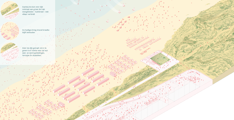
Figure 1: Example of a possible extended dune landscape as one of the possible coastal protection measures in the preferred alternative ‘Seaward’ for the beach zones. Image ©Hoogtij(d)
