J.K. Leenders1*, C.W. Wegman1, W. Bodde2, M.Smit2, A.Verheijen2
1 HKV Lijn in water,
Introduction
In 2015 the coastline between Camperduin and Petten (NL) was reinforced because the sea defence did not comply to the Dutch safety standards anymore. A soft sandy solution was chosen to improve the flood safety and spatial quality (Figure 1). A natural barrier of 36 million cubic metres of sand on the seaside of the dike was built. After construction, a three-year interdisciplinary study was carried out in the area to monitor the development of nature and morphology and the perception of this development. The aim of the monitoring was to learn about efficient sand-nourishment with added value for nature and leisure.
One of the research questions in the study comprised whether optimisations can be pointed out at the design and construction of a sandy nourishment, specifically with respect to aeolian sediment loss and sea level rise. In the design and construction of the dune and the safety profile for the Hondsbossche Dunes aeolian loss over a period of 20 years and climate change over a period of 50 years was compensated for with a total volume of about 1,8 Mm3 of sand. Was, in view of the current processes, this necessary or is it likely that the natural process of dune growth will adequately compensate for the aeolian loss over the next 20 years, and sea level rise and soil subsidence over the next 50 years?
Methodology
Dune growth rates, beach erosion rates and wind data were analysed for the monitoring period to study the morphological development. This was based on 9 laser altimetry measurements (LiDAR) and aerial photographs of the zone above the waterline. Also half-yearly site visits were conducted. The ecological development was monitored and literature study was done. Morphodynamic calculations were done with XBeach and Duros+ .
Results
In the analysis it was taken into account that the dune growth during the monitoring period, the period shortly after construction of the dunes, is expected to be higher than the coming years. Based on the analysis it
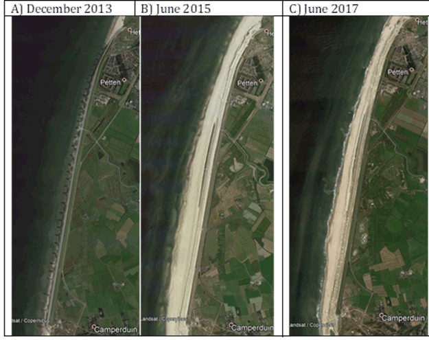
Figure 1: Satellite imagery of the coastline between Camperduin and Petten (NL) A) Hondsbossche and Pettemer sea dike (December 2013) B) Hondsbossche Dunes a few months after construction (June 2015) and C) Hondsbossche Dunes 2 years after construction (June 2017) Source: Google Earth Pro.
is expected that aeolian deposition in the entire area of the Hondsbossche Dunes is large enough to offset the aeolian sediment loss for the next 20 years and relative sea level rise for the next 50 years. In hindsight, construction of the compensation volume for aeolian losses and sea level rise for the next 50 years would therefore not have been necessary.
A boundary condition for this result is a constant or growing profile below 3 m + NAP (foreshore, intertidal area, beach). This fits within the current safety policy of the coastal zone in the Netherlands in which the coastline as determined in 1990 is maintained by regular nourishments. Under this condition (maintaining the coastal zone below 3 m + NAP), aeolian deposition can compensate the sea level rise to a speed of 1 m per century.
In new projects with sandy nourishments it is advised to use the most up-to-date forecasts on sea level rise, to consider the sea level rise that has occurred up to that point and weighing up whether additional compensation for sea level rise is necessary or an adaptive policy is preferred.
I. Surname1*, F.N. Another-Surname2 , Y. Next-Surname2
1 University Name, Country; 2 Organization Name, Country
* Corresponding author: mail.name@organization.org
